
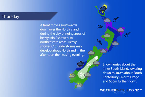
A cold front combines with a warm front coming out of a low in the Tasman Sea on Thursday over central South Island regions and delivers some warm advection snow to inland areas. Meanwhile an occluded front moves southwards over the North Island during the day.
Morning rain (possibly heavy) for the upper North Island then easing to the odd shower in the afternoon, brisk east to northeasterly winds ease. Northland may see a second wave of heavy showers / downpours in the afternoon with a chance of thunderstorms then easing in the evening.
Rain develops in the morning about the lower North Island in the west, freshening east to southeasterly winds. Rain develops in the morning along the east coast bringing a chance of heavy falls, easing overnight. Breezy east to northeasterly winds.
Mostly cloudy about Wellington, southerlies strengthen from afternoon bringing in patchy rain.
Cloudy about Nelson and Marlborough with southeasterly winds developing in the morning, rain moves in overnight with winds becoming strong.
A cold southerly change develops in the morning about Canterbury bringing rain, easing to drizzle at times late afternoon. Snow to 800m in the morning, lowering to 400m in the afternoon about South Canterbury, 500m about Mid Canterbury and 600m about North Canterbury.
Areas of morning rain ease for the West Coast to showers in the afternoon, southeasterlies freshen late morning.
Early showers clear about Southland then expect cloudy periods, southerlies tend easterly by evening. Otago sees morning rain ease to the odd drizzle patch, snow flurries to 400m, perhaps even 300m at times. Southeasterly winds.
Blue – Heavy form of precipitation or cold temperatures, typically below 1 to 2 degrees celsius.
Purple – Strong winds.
Yellow – Temperatures around the mid 20 degree mark or over.
Not all regions and towns have been mentioned above. For specific 10 day information for your city, town, rural community or island please see the 1500 forecasts on our homepage!
– Aaron Wilkinson, WeatherWatch.co.nz
Comments
Latest Video

Weekend Newsfeed: Winter weather in the south, high pressure in the north
A cold change is affecting the lower half of the South Island Saturday bringing snow to the hills and ranges…
Related Articles
Weekend Newsfeed: Winter weather in the south, high pressure in the north
A cold change is affecting the lower half of the South Island Saturday bringing snow to the hills and ranges…

VIDEO: 7 Day NZ RainWatch: Who gets rain, who misses out
A cold front will bring winter-like weather into the lower South Island on Saturday but won’t make to the top…

MetService Auckland rain radar offline – helicopter called in
Aucklanders may have noticed the rain radar isn’t working this week. MetService has provided us with an update ahead of…


Add new comment