
A westerly quarter airflow covers the country on Saturday although a low forms out to the east influencing a southwest change about the east coast of the South Island.
Any early showers clear the upper North Island then expect a mix of sun and cloud with west to southwesterly winds. Mostly sunny after morning cloud breaks away for the lower western North Island, late evening or overnight a few patchy showers move in. West to northwesterly winds. Sunny with light winds along the east coast, afternoon sea breezes about Hawkes Bay and Gisborne.
Mostly sunny for Wellington with some high cloud possible. North to northwesterly winds, breezy from afternoon.
Mostly sunny for Nelson and Marlborough with light winds picking up from the north ot northwest in the afternoon. Mostly sunny with some high cloud in Canterbury, late afternoon or evening isolated showers develop roughly Banks Peninsula southwards bringing the chance of a heavy fall, perhaps even a thunderstorm. Light winds tend southerly during the afternoon.
Mostly cloudy along the West Coast with patchy showers, possibly heavy from late afternoon / evening. Westerly winds. Morning sunny spells for Southland and Otago with the chance of a shower. Showers more likely in the afternoon with the chance of a heavy fall / thunderstorm then clearing at night. Westerly winds.
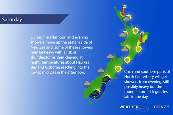
Blue – Heavy form of precipitation – or – low temperatures, typically below 1 to 2 degrees celsius.
White – Snow
Purple – Strong winds.
Yellow – Temperatures around the mid 20 degree mark or over.
Not all regions and towns have been mentioned above. For specific 10 day information for your city, town, rural community or island please see the 1500 forecasts on our homepage!
– Aaron Wilkinson, WeatherWatch.co.nz
Comments
Latest Video

VIDEO: High pressure to cross NZ, but a westerly change behind it
Colder air takes us into the weekend but next week milder sub-tropical winds and westerlies are likely as high pressure…
Related Articles
VIDEO: High pressure to cross NZ, but a westerly change behind it
Colder air takes us into the weekend but next week milder sub-tropical winds and westerlies are likely as high pressure…

Thursday Newsfeed: Colder air heads north
A colder southerly flow is spreading up and across NZ today bringing frosty weather to inland parts of both main…

VIDEO: !Frost Alert as high pressure brings colder air, a change possible next week
Massive high pressure near Tasmania is bringing in a colder southerly for NZ today and that means frosts over the…


Add new comment