
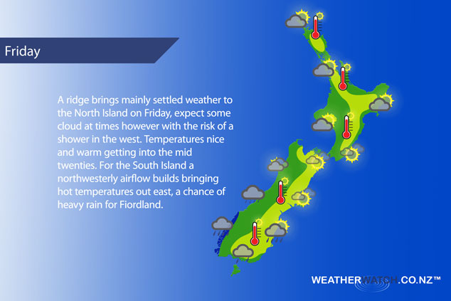
A ridge lies over the North Island on Friday, expect a northwesterly airflow further south with a front moving onto the lower South Island.
A mix of sun and cloud for the upper North Island, low risk of an isolated shower late afternoon / evening, mainly dry otherwise. Light winds in the morning then afternoon sea breezes. Sunny spells for the lower western North Island with a touch of high cloud from afternoon, light winds in the morning then afternoon west to northwest winds. May be a brief shower for Taranaki early afternoon otherwise mainly dry.
Mostly sunny along the east coast, there may be a few early showers about Gisborne. Northeasterlies for the Wairarapa and Hawkes Bay, winds tend southeast about Gisborne then northeast there in the evening. Sunny areas and some high cloud for Wellington, breezy northerly winds.
Mostly sunny about Nelson and Marlborough with some high cloud, northwesterly winds for Marlborough. Southwesterlies tend northerly around midday for Nelson. Mostly sunny in Canterbury with some high cloud and afternoon high’s in the high twenties, perhaps even early thirties. Northwesterlies for most however winds tending northeasterly about the coast.
Mostly cloudy along the West Coast, there may be a shower or two about. Some rain moves into Fiordland during the afternoon with the chance of a heavy fall or two. Northwesterly winds. Thick high cloud about Southland with a spot of rain possible then a few showers from afternoon as northwest winds change southwest. Further north into Otago there may be a spot of rain in the morning then sunny areas breaking through high cloud in the afternoon, northwesterlies change southwest late afternoon or evening bringing the risk of a brief shower otherwise staying fairly dry.
Blue – Heavy form of precipitation – or – low temperatures, typically below 1 to 2 degrees celsius.
White – Snow
Purple – Strong winds.
Yellow – Temperatures around the mid 20 degree mark or over.
Not all regions and towns have been mentioned above. For specific 10 day information for your city, town, rural community or island please see the 1500 forecasts on our homepage!
– Aaron Wilkinson, WeatherWatch.co.nz
Comments
Latest Video

Sunday Newsfeed: Low pressure areas increase offshore near northern NZ in days ahead
A light easterly kicks in to the north of the North Island on Sunday as high pressure moves south east…
Related Articles
Sunday Newsfeed: Low pressure areas increase offshore near northern NZ in days ahead
A light easterly kicks in to the north of the North Island on Sunday as high pressure moves south east…

VIDEO: 7 Day NZ RainWatch: Who gets rain, who misses out
A cold front will bring winter-like weather into the lower South Island on Saturday but won’t make to the top…

MetService Auckland rain radar offline – helicopter called in
Aucklanders may have noticed the rain radar isn’t working this week. MetService has provided us with an update ahead of…


Add new comment