InfoGraphic: The Big Picture for Wednesday / Thursday
8/10/2019 6:00pm

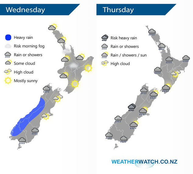
Frontal zones affect the South Island today with heavy rain in the west, northwesterlies for the North Island with mainly settled conditions. A low pressure system to the west flings a front over the South Island on Thursday meanwhile a humid northerly airflow for the North Island brings areas of patchy rain or drizzle in the west, drier weather for the east.
Sunny spells for the west and north of the North Island today, there may be some morning fog for inland areas. Sunny and warm out east. Heavy rain for the West Coast of the South Island, mainly dry in the east with high cloud. Southland and Otago has patchy rain or drizzle, setting in more after midday.
Patchy rain or drizzle for western regions of the North Island on Thursday, mainly dry out east with high cloud however there could be a spot of rain spread from the west at times. Rain for the West Coast of the South Island, there may be a heavy fall or two. Rain about Southland spreads into Otago during the afternoon. Mainly dry with high cloud about Canterbury, late afternoon or evening some rain moves in. Nelson and Marlborough have spits of rain or showers, more persistent rain develops in the evening then clearing overnight.
By Weather Analyst Aaron Wilkinson – WeatherWatch.co.nz
Comments
Latest Video

ClimateWatch: MAY’s outlook as El Niño ends, NEUTRAL pattern arrives (+Video & 13 Maps)
El Niño may be technically gone but the weather pattern it created is still with our part of the world. By…
Related Articles
ClimateWatch: MAY’s outlook as El Niño ends, NEUTRAL pattern arrives (+Video & 13 Maps)
El Niño may be technically gone but the weather pattern it created is still with our part of the world. By…

Weekend Newsfeed: High pressure starts to grow around NZ, easterlies in the north
The cooler SW flow of this past week is going to fade more going into the weekend as high pressure…

VIDEO: NZ RainWatch -Not much coming next 7 days
High pressure is the main feature driving NZ’s weather for the next 10 days but low pressure is trying to…


Add new comment