InfoGraphic: The Big Picture for Wednesday / Thursday
3/09/2019 7:00pm

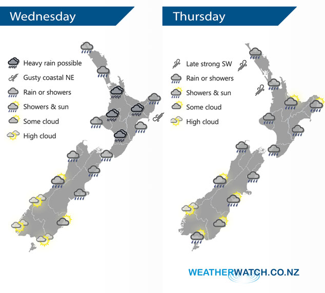
A low centred just to the northwest of the North Island drags down an easterly quarter airflow over New Zealand today bringing mainly unsettled weather. The best weather will be about Southland and Fiordland. This low moves over the North Island on Thursday bringing unsettled conditions, southwesterlies further south.
Rain or showers for most of the North Island today, rain may be heavy about central areas. Rain develops about Nelson / Marlborough this morning then spreading into Canterbury during the afternoon. Plenty of high cloud about the far south, mainly dry although coastal Otago sees some drizzle by evening then a chance of overnight rain.
Rain or showers for much of the North Island on Thursday, becoming heavy from afternoon about Northland down to Waikato in the evening as southwesterlies strengthen. Rain or showers for much of the upper South Island, becoming intense for inland areas from mid afternoon then easing overnight. The lower South Island has a mainly dry day, perhaps a shower or two about Southland.
By Weather Analyst Aaron Wilkinson – WeatherWatch.co.nz
Comments
Latest Video

Weekend Newsfeed: Winter weather in the south, high pressure in the north
A cold change is affecting the lower half of the South Island Saturday bringing snow to the hills and ranges…
Related Articles
Weekend Newsfeed: Winter weather in the south, high pressure in the north
A cold change is affecting the lower half of the South Island Saturday bringing snow to the hills and ranges…

VIDEO: 7 Day NZ RainWatch: Who gets rain, who misses out
A cold front will bring winter-like weather into the lower South Island on Saturday but won’t make to the top…

MetService Auckland rain radar offline – helicopter called in
Aucklanders may have noticed the rain radar isn’t working this week. MetService has provided us with an update ahead of…


Add new comment