
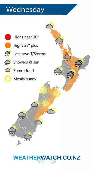
A weak ridge of high pressure stretches out over New Zealand on Wednesday, mainly settled however unstable conditions may develop for some North Island areas during afternoon.
A mix of sun and cloud for the North Island on Wednesday, there may be a morning shower about East Cape / Gisborne / Taranaki and Kapiti then clearing away. Isolated showers late afternoon / evening about Waikato, Bay Of Plenty (especially inland) and the ranges of Gisborne / Hawkes Bay. These showers may become heavy with thunderstorms then easing overnight.
Mostly sunny for the upper South Island, some cloud the further south you go. A few showers along the West Coast, Southland and Otago ease during the day, mainly dry by evening.
By Weather Analyst Aaron Wilkinson – WeatherWatch.co.nz
Comments
Latest Video

VIDEO: NZ: Another Autumn change this week as high pressure remains offshore
A low with sub-tropical connections will flirt with the eastern North Island over the next couple of days but the…
Related Articles
VIDEO: NZ: Another Autumn change this week as high pressure remains offshore
A low with sub-tropical connections will flirt with the eastern North Island over the next couple of days but the…

Monday Newsfeed: The forecast as we say goodbye to April, hello to May…
In true Autumn style the big picture weatherwise around New Zealand this week is a bit of “everything off the…

Meteors – Your Eyewitness Reports!
WeatherWatch.co.nz receives meteor reports from all over New Zealand and the globe, 24/7/365. **CASUAL COMMENTS**If you’ve seen something in the…


Add new comment