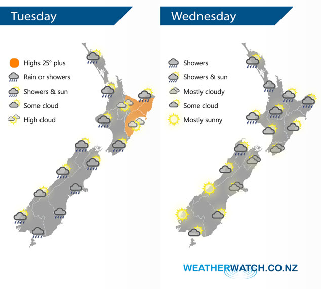
InfoGraphic: The Big Picture for Tuesday / Wednesday
9/03/2020 6:00pm

Western parts of the North Island get the odd shower in a westerly airflow today, drier out east. Cool southerlies for the South Island bring rain or showers in the east, clearing conditions out west. A southwesterly airflow lies over New Zealand on Wednesday, potentially becoming unstable for Buller and some parts of the upper North Island in the afternoon.
Sunny spells and the odd shower for western parts of the North Island today, mainly dry further east although there may be a few clearing morning showers for eastern Bay Of Plenty. Any morning showers clear the West Coast of the South Island then becoming mostly sunny, in the east rain or showers about Southland / Otago push northwards into Canterbury during the morning then Marlborough in the afternoon with south to southwest winds.
Conditions may be dry in the morning for most of the upper North Island on Wednesday however isolated showers move in during the afternoon, isolated heavy falls possible for southern parts of Auckland and Waikato. Sunny spells in the east, risk of a shower. Wellington is mostly cloudy with any morning showers clearing, some sun may break through from afternoon. Mostly sunny for the West Coast, isolated showers develop for Buller in the afternoon. Mostly cloudy for Canterbury through to Nelson, Nelson has the odd shower. Morning cloud clears Southland and Otago then becoming mostly sunny.

By Weather Analyst Aaron Wilkinson – WeatherWatch.co.nz


Add new comment