InfoGraphic: The Big Picture for Tuesday / Wednesday
3/06/2019 7:00pm

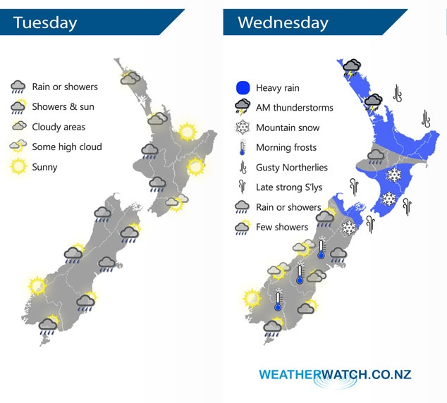
A northwesterly airflow lies over the North Island today meanwhile a front pushes northwards over the South Island bringing in a southwest change. A reasonably deep low pressure system moves over the North Island and upper South Island on Wednesday bringing unsettled weather, a ridge of high pressure brings more settled conditions further south.
Mostly cloudy for the western North Island today with a few showers mainly south of about Auckland, the Bay Of Plenty sees some morning sun then cloud increases from afternoon. Mostly sunny in the east. Morning showers clear South Westland, clearing North Westland / Buller during the afternoon and evening. A period of rain or showers moves through the lower South Island early morning, Canterbury this morning / afternoon then finally into Marlborough this evening.
Wednesday sees rain for the upper North Island in the morning with heavy falls and possible thunderstorms, finally easing about Bay Of Plenty late afternoon. The odd shower about the lower North Island then SSE winds strengthen from afternoon bringing rain with heavy falls which gradually pushes northwards in the evening. Overnight snow in the ranges about the lower North Island to 700m. Fairly cloudy for the upper South Island with some rain or showers, rain heavy about Nelson / Marlborough then clearing overnight. Snow may fall in the ranges behind Kaikoura / Marlborough down to 600 or perhaps 500m before clearing overnight. The lower South Island is a bit more settled with some high cloud in the west, cloudy areas in the east with a few showers for Southland.
By Weather Analyst Aaron Wilkinson – WeatherWatch.co.nz
Comments
Latest Video

Sunday Newsfeed: Low pressure areas increase offshore near northern NZ in days ahead
A light easterly kicks in to the north of the North Island on Sunday as high pressure moves south east…
Related Articles
Sunday Newsfeed: Low pressure areas increase offshore near northern NZ in days ahead
A light easterly kicks in to the north of the North Island on Sunday as high pressure moves south east…

VIDEO: 7 Day NZ RainWatch: Who gets rain, who misses out
A cold front will bring winter-like weather into the lower South Island on Saturday but won’t make to the top…

MetService Auckland rain radar offline – helicopter called in
Aucklanders may have noticed the rain radar isn’t working this week. MetService has provided us with an update ahead of…


Add new comment