
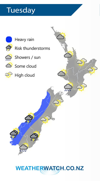
A northwesterly airflow lies over the country on Tuesday, a cold front pushes onto the lower South Island during the morning then slowly moving northwards reaching the lower North Island overnight.
A mix of sun and cloud for the western North Island, high cloud out east. A light shower or two may affect Kapiti, rain moves into the southwestern North Island overnight.
Heavy rain about South Westland spreads into North Westland during the afternoon, easing later in the evening, thunderstorms are possible about South Westland in the morning. Dry to start about Southland and Otago, showers develop in the afternoon possibly heavy with thunderstorms for coastal Otago. Canterbury and Marlborough have a mainly sunny day with some high cloud.
By Weather Analyst Aaron Wilkinson – WeatherWatch.co.nz
Comments
Latest Video

VIDEO: NZ’s Autumn showers + sub-tropical developments
NZ has a classic Autumn sou-wester today and this eases into Friday and the weekend. Next week low pressure forms…
Related Articles
VIDEO: NZ’s Autumn showers + sub-tropical developments
NZ has a classic Autumn sou-wester today and this eases into Friday and the weekend. Next week low pressure forms…

Thursday Newsfeed: A south-west flow across the country
A south-westerly flow has spread across NZ and will continue to do so for Thursday, Friday and Saturday. Windiest weather…

ClimateWatch: MAY’s outlook as El Niño ends, NEUTRAL pattern arrives (+Video & 13 Maps)
El Niño may be technically gone but the weather pattern it created is still with our part of the world. By…


Add new comment