
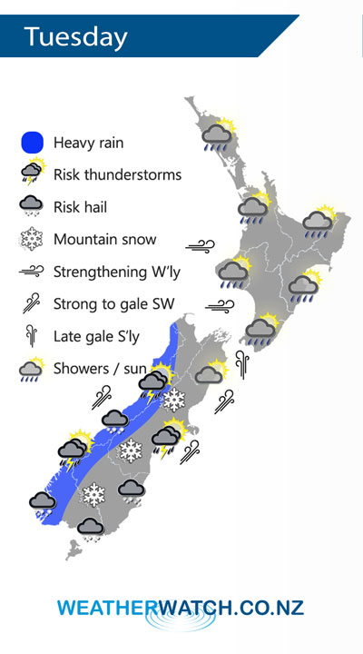
A southwest airflow lies over New Zealand on Tuesday, a rapidly approaching front and low combination move into the lower South Island from afternoon then pushes northwards in the evening bringing in a cold change.
Showers for most of the day along the western side of the North Island although long dry spells develop in the afternoon for Bay Of Plenty and Waikato down through to Kapiti, perhaps becoming mainly dry before showers move back in at night. Rain or showers for Wairarapa and perhaps southern Hawkes Bay in the morning then drying out during the afternoon, drier further north along the east coast.
Showers then heavy rain with a chance of thunderstorms pushing northwards along the West Coast of the South Island during the day. Heavy showers with a risk of hail move into Southland early afternoon reaching North Canterbury in the evening, thunderstorms possible for Canterbury with the change. Snow lowers to 400m about Southland / Otago and 500m for Canterbury as the cold change pushes through.
By Weather Analyst Aaron Wilkinson – WeatherWatch.co.nz
Comments
Latest Video

VIDEO: Anzac Day + weather to next Tuesday
Anzac Day looks mild for many parts of NZ with windy nor’westers gusting to gale force for some. Many regions…
Related Articles

Weekend Newsfeed: Weather improves for most as high pressure drifts in
Saturday – powerful high pressure starts to move in from Australia and will still mean a few showers along the…

Anzac Day Newsfeed: Severe gales, heavy rain for some, settled for others
Updated 4am — High pressure over northern NZ moves east of the country on Thursday while a storm south of…
VIDEO: Anzac Day + weather to next Tuesday
Anzac Day looks mild for many parts of NZ with windy nor’westers gusting to gale force for some. Many regions…


Add new comment