InfoGraphic: The Big Picture for Thursday / Friday
22/01/2020 6:00pm

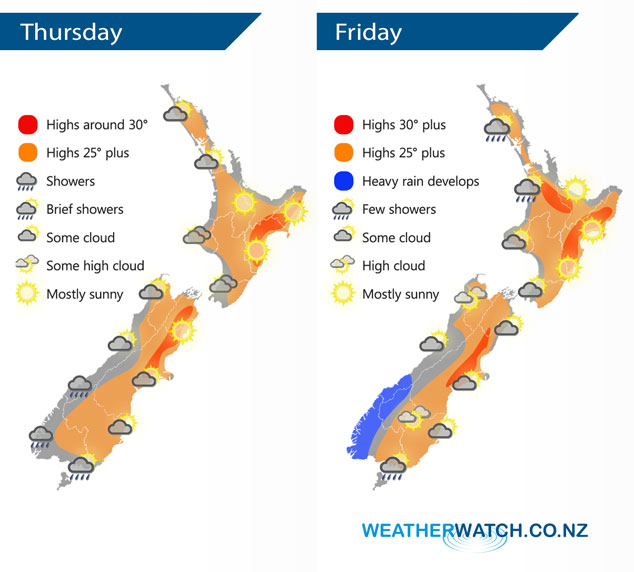
A very weak front disintegrates over the South Island today as an anticyclone starts to regain dominance over the country. Mainly anticyclonic for New Zealand again on Friday bringing more settled weather, still plenty of morning cloud about for some. A front approaches to the west moving onto the lower South Island overnight.
Morning cloud for Northland and Auckland breaks to mostly sunny weather this afternoon, staying mostly cloudy for the southwestern corner, perhaps even a shower or two. Mostly sunny from Bay Of Plenty down through to Wairarapa in the east. Showers for the southwestern corner of the South Island ease in the morning and clear away, mostly sunny in the east then some cloud thickens for inland parts of Canterbury from afternoon.
Morning cloud for the western North Island then breaking to increasing sunny areas from afternoon, any early showers for western Auckland / Northland clear away. Mostly sunny for the eastern North Island. Morning cloud breaks for the eastern South Island then expect some high cloud. Sunny spells in the west, the odd shower moves into Fiordland from afternoon then rain develops there later in the evening / overnight with possible heavy falls. Southland has a dry day, some rain develops overnight.
By Weather Analyst Aaron Wilkinson – WeatherWatch.co.nz
Comments
Latest Video

VIDEO: NZ RainWatch -Not much coming next 7 days
High pressure is the main feature driving NZ’s weather for the next 10 days but low pressure is trying to…
Related Articles

Weekend Newsfeed: High pressure starts to grow around NZ, easterlies in the north
The cooler SW flow of this past week is going to fade more going into the weekend as high pressure…
VIDEO: NZ RainWatch -Not much coming next 7 days
High pressure is the main feature driving NZ’s weather for the next 10 days but low pressure is trying to…

VIDEO: NZ’s Autumn showers + sub-tropical developments
NZ has a classic Autumn sou-wester today and this eases into Friday and the weekend. Next week low pressure forms…


Add new comment