InfoGraphic: The Big Picture for Thursday / Friday
20/11/2019 6:00pm

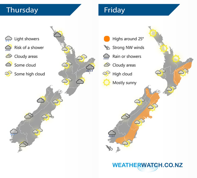
A ridge of high pressure lies over the country today extending out from an anticyclone in the Tasman Sea. This anticyclone continues to cast a ridge of high pressure over the North Island on Thursday however further south expect a north to northwesterly airflow.
Mostly sunny for the upper / western North Island today, some morning mid level cloud for Northland then clearing. Some cloud for the east coast, a light shower or two possible for Hawkes Bay and Gisborne. Cloudy areas for the West Coast of the South Island, light showers about Fiordland. Mostly sunny with some high cloud in the east. Cloudy areas about Southland, a spit or shower possible for coastal parts at times otherwise mainly dry.
Mostly sunny for a majority of the North Island on Friday, some high cloud likely at times though. Winds are light in the east and tending west to southwest in the west. Sunny areas and some high cloud for most of the South Island, getting into South Westland skies are cloudier with some rain gradually moving into Fiordland.
By Weather Analyst Aaron Wilkinson – WeatherWatch.co.nz
Comments
Latest Video

VIDEO: NZ’s Autumn showers + sub-tropical developments
NZ has a classic Autumn sou-wester today and this eases into Friday and the weekend. Next week low pressure forms…
Related Articles
VIDEO: NZ’s Autumn showers + sub-tropical developments
NZ has a classic Autumn sou-wester today and this eases into Friday and the weekend. Next week low pressure forms…

Thursday Newsfeed: A south-west flow across the country
A south-westerly flow has spread across NZ and will continue to do so for Thursday, Friday and Saturday. Windiest weather…

ClimateWatch: MAY’s outlook as El Niño ends, NEUTRAL pattern arrives (+Video & 13 Maps)
El Niño may be technically gone but the weather pattern it created is still with our part of the world. By…


Add new comment