InfoGraphic: The Big Picture for Thursday / Friday
16/10/2019 6:00pm

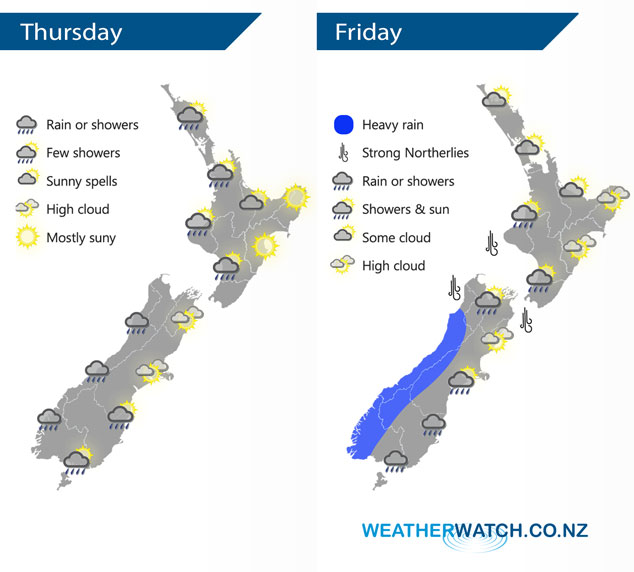
A southwesterly airflow lies over the country today, easing over the South Island then a warm front moves in from the Tasman Sea hitting the West Coast late evening. A large low deepens in the Tasman Sea on Friday bringing unsettled weather to the South Island, heavy rain for the West Coast.
Sunny spells for the western North Island today, the odd shower possible also. Mainly sunny and dry weather in the east. The odd light shower develops for the South Islands West Coast by midday then turning to rain by evening. High cloud in the east, the odd shower about Southland spreads into parts of Otago during the afternoon. Some scattered rain by evening from Mid Canterbury down through to Otago, perhaps Southland also.
A mix of sun and increasing cloud for the western North Island on Friday, the odd shower at times from Taranaki down through to Kapiti. Overnight rain or showers for all. Dry for most of the east coast with northwesterlies, spots of rain may spread into Wairarapa at times especially evening. Heavy rain for the West Coast of the South Island, torrential falls possible at times then easing later in the evening or overnight. Scattered rain spreads into eastern areas at times during the day especially Banks Peninsula southwards.
By Weather Analyst Aaron Wilkinson – WeatherWatch.co.nz
Comments
Latest Video

VIDEO: Anzac Day + weather to next Tuesday
Anzac Day looks mild for many parts of NZ with windy nor’westers gusting to gale force for some. Many regions…
Related Articles

Weekend Newsfeed: Weather improves for most as high pressure drifts in
Saturday – powerful high pressure starts to move in from Australia and will still mean a few showers along the…

Anzac Day Newsfeed: Severe gales, heavy rain for some, settled for others
Updated 4am — High pressure over northern NZ moves east of the country on Thursday while a storm south of…
VIDEO: Anzac Day + weather to next Tuesday
Anzac Day looks mild for many parts of NZ with windy nor’westers gusting to gale force for some. Many regions…


Add new comment