InfoGraphic: The Big Picture for Thursday / Friday
10/07/2019 7:00pm

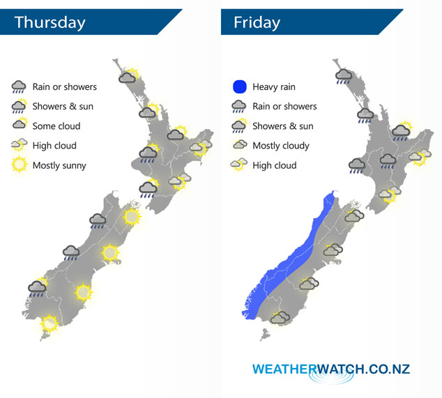
A light westerly quarter airflow lies over New Zealand today. A front passes from west to east over the country on Friday, arriving about eastern regions late afternoon or evening.
A mix of sun and cloud for the upper North Island today, chance of an isolated shower or two otherwise mainly dry. Cloudy periods and the odd shower for the lower western North Island, dry along the east coast with a mostly sunny day in store after any morning high cloud clears. Patchy rain or showers for the South Islands West Coast, easing from afternoon. Sunny for the east coast after any morning high cloud clears.
A mainly dry morning for western New Zealand on Friday then rain develops around midday, becoming heavy for some. Perhaps a thunderstorm in the afternoon for western parts of the North Island then easing in the evening as northerlies change northwest or westerly. High cloud for eastern regions, a few spots of rain late afternoon or evening as a front passes over, northeasterly winds tend north to northwest later in the day.
By Weather Analyst Aaron Wilkinson – WeatherWatch.co.nz
Comments
Latest Video

Sunday Newsfeed: Low pressure areas increase offshore near northern NZ in days ahead
A light easterly kicks in to the north of the North Island on Sunday as high pressure moves south east…
Related Articles
Sunday Newsfeed: Low pressure areas increase offshore near northern NZ in days ahead
A light easterly kicks in to the north of the North Island on Sunday as high pressure moves south east…

VIDEO: 7 Day NZ RainWatch: Who gets rain, who misses out
A cold front will bring winter-like weather into the lower South Island on Saturday but won’t make to the top…

MetService Auckland rain radar offline – helicopter called in
Aucklanders may have noticed the rain radar isn’t working this week. MetService has provided us with an update ahead of…


Add new comment