
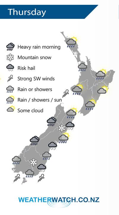
Overnight tonight a cold southwest change moves onto the lower South Island, this change pushes northwards moving onto the lower North Island midday Thursday.
Conditions are dry to start about the western North Island on Thursday, rain or showers moves into the southwestern corner during the morning then further north around midday. Sunny areas and some high cloud in the east, some rain develops about Wairarapa in the afternoon then a few showers may make it into Hawkes Bay in the evening with a southwest change.
Heavy morning rain for the West Coast of the South Island then easing. Dry to start about Canterbury then a fresh southwest change pushes northwards during the morning bringing showers, some may be heavy with a risk of hail. Some snow develops about the ranges of North Canterbury down to 500-600m. Rain or showers may be heavy in the morning about the far south with a risk of hail then easing, fresh cold southwesterlies and snow to 400m in the morning then gradually lifting.
By Weather Analyst Aaron Wilkinson – WeatherWatch.co.nz
Comments
Latest Video

VIDEO: NZ RainWatch -Not much coming next 7 days
High pressure is the main feature driving NZ’s weather for the next 10 days but low pressure is trying to…
Related Articles

Weekend Newsfeed: High pressure starts to grow around NZ, easterlies in the north
The cooler SW flow of this past week is going to fade more going into the weekend as high pressure…
VIDEO: NZ RainWatch -Not much coming next 7 days
High pressure is the main feature driving NZ’s weather for the next 10 days but low pressure is trying to…

VIDEO: NZ’s Autumn showers + sub-tropical developments
NZ has a classic Autumn sou-wester today and this eases into Friday and the weekend. Next week low pressure forms…


Add new comment