InfoGraphic: The Big Picture for Saturday / Sunday
14/02/2020 2:05am

A large anticyclone lies to the east of New Zealand on Saturday meanwhile there’s a deep low (ex TC Uesi) in the Tasman Sea, in between a northeasterly airflow flows over the country. Ex TC Uesi moves towards the lower South Island on Sunday, a northwest airflow further north.
Mainly dry across the North Island on Saturday, there may be a light shower or drizzle patch about some northeastern coastlines. Skies in the east are mostly cloudy meanwhile in the west expect high cloud. For the eastern South Island morning cloud breaks to sunny areas and high cloud. Some cloud in the west, risk of a shower about South Westland, more likely overnight.
Cloudy areas for northeastern parts of the North Island on Sunday, there may be a light shower or drizzle patch also. Mainly dry elsewhere with high cloud. Cloudy for the West Coast of the South Island with rain, heavy south of about Greymouth with strong northeasterlies. Some rain or showers about the lower South Island for a time, rain may be briefly heavy about coastal Southland. Mainly dry with some high cloud for the rest of the eastern South Island.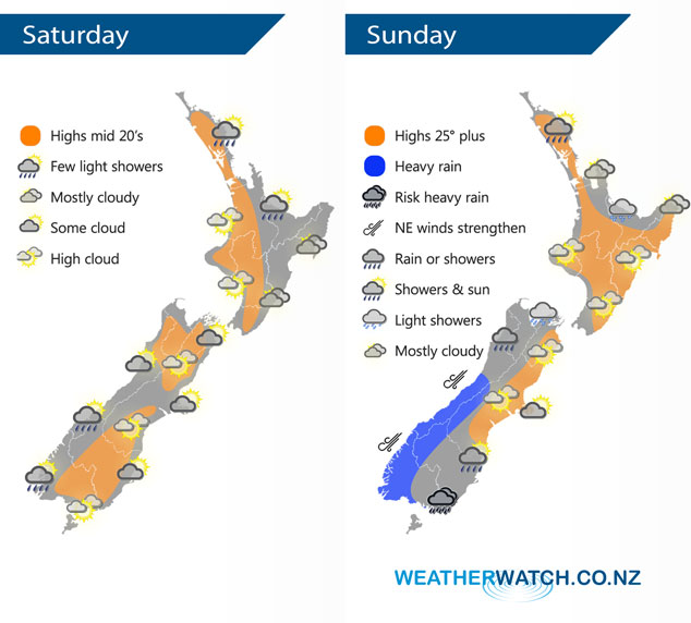
By Weather Analyst Aaron Wilkinson – WeatherWatch.co.nz
Comments
Latest Video

VIDEO: NZ: Another Autumn change this week as high pressure remains offshore
A low with sub-tropical connections will flirt with the eastern North Island over the next couple of days but the…
Related Articles

Wednesday Newsfeed: The next southerly pounces
Snow on the southern ranges, a windier south to south-west change moving into NZ, rain around the South Island and…

Tuesday Newsfeed: A fresh southerly is approaching New Zealand
Today we’re in between systems. For the last day of April it’s not too bad for most. But there’s a…
VIDEO: NZ: Another Autumn change this week as high pressure remains offshore
A low with sub-tropical connections will flirt with the eastern North Island over the next couple of days but the…


Add new comment