InfoGraphic: The Big Picture for Saturday / Sunday
7/02/2020 2:17am

A front pushes northwards over the South Island during Saturday, reaching the lower North Island in the evening. A southwest airflow lies over the country on Sunday, moving around a large high in the south Tasman Sea.
A mix of sun and cloud for the upper / western North Island on Saturday, there may be the odd shower about also with northwesterly winds tending southwest during the afternoon. Mainly sunny conditions for the east coast. Morning rain about Southland / Otago then easing to showers and dry spells from afternoon. Dry at first further north for the South Island then showers push northwards during the morning / afternoon with a southwest change. Nelson has a mainly dry day.
Mostly sunny for the upper / western North Island on Sunday, there may be some morning cloud about then breaking. The odd shower for the east coast, Wairarapa may be mainly dry apart from the risk of an early shower. Cloud and the odd light shower / drizzle patch for Nelson, mostly sunny elsewhere for the east of the South Island but expect some morning cloud then breaking away. South Westland has a mainly sunny day. Southland is mostly cloudy with the odd coastal shower.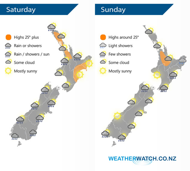
By Weather Analyst Aaron Wilkinson – WeatherWatch.co.nz
Comments
Latest Video

ClimateWatch: MAY’s outlook as El Niño ends, NEUTRAL pattern arrives (+Video & 13 Maps)
El Niño may be technically gone but the weather pattern it created is still with our part of the world. By…
Related Articles

Thursday Newsfeed: A south-west flow across the country
A south-westerly flow has spread across NZ and will continue to do so for Thursday, Friday and Saturday. Windiest weather…
ClimateWatch: MAY’s outlook as El Niño ends, NEUTRAL pattern arrives (+Video & 13 Maps)
El Niño may be technically gone but the weather pattern it created is still with our part of the world. By…

Wednesday Newsfeed: The next southerly pounces
Snow on the southern ranges, a windier south to south-west change moving into NZ, rain around the South Island and…


Add new comment