InfoGraphic: The Big Picture for Saturday / Sunday
18/10/2019 2:50am

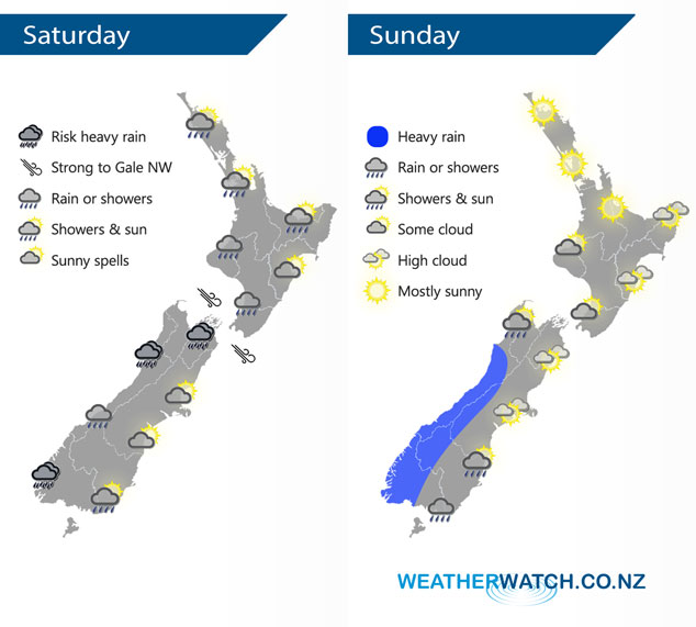
A low pressure system passes out to the east of New Zealand on Saturday, weakening as it moves away. A northerly airflow builds on Sunday ahead of a front which moves into the lower South Island in the morning then finally starts to shift northwards in the evening.
Rain or showers for western parts of New Zealand eases during Saturday, only the odd shower remains with long dry spells once evening arrives. Eastern New Zealand stays drier however rain moves through Wairarapa and perhaps southern Hawkes Bay till late afternoon. Expect the odd shower for Southland and Otago but many long dry periods and some sun too.
A fairly settled day for the North Island on Sunday, some cloud in the southwest brings the low risk of a shower or two in the morning otherwise mainly dry. Cloudy for the West Coast with heavy rain pushing into Fiordland in the morning then moving northwards in the evening. Southland doesn’t see showers till mid or late afternoon then a few move into Otago during the evening.
By Weather Analyst Aaron Wilkinson – WeatherWatch.co.nz
Comments
Latest Video

VIDEO: Anzac Day + weather to next Tuesday
Anzac Day looks mild for many parts of NZ with windy nor’westers gusting to gale force for some. Many regions…
Related Articles

Weekend Newsfeed: High pressure arrives, dragging in some cloud, more settled nationwide
Sunday – High pressure crosses NZ properly and winds ease for many regions and most (but not all) showers will…

Anzac Day Newsfeed: Severe gales, heavy rain for some, settled for others
Updated 4am — High pressure over northern NZ moves east of the country on Thursday while a storm south of…
VIDEO: Anzac Day + weather to next Tuesday
Anzac Day looks mild for many parts of NZ with windy nor’westers gusting to gale force for some. Many regions…


Add new comment