InfoGraphic: The Big Picture for Monday / Tuesday
8/09/2019 7:00pm

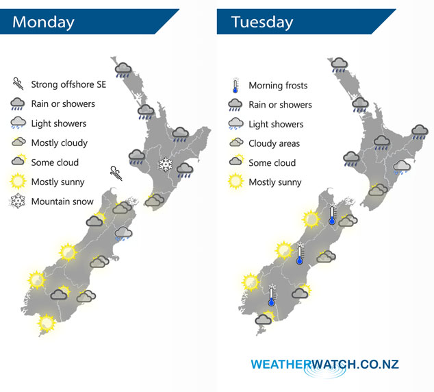
A large low pressure system in the Tasman Sea draws in an easterly quarter airflow over New Zealand today. East to southeasterly winds continue over the North Island on Tuesday, expect a ridge of high pressure further south.
Most of the North Island sees rain or showers today, just the Wairarapa, Wellington and Kapiti is looking mainly dry but there still may be a light shower or two. Expect snow about the Central Plateau and the ranges of Gisborne down to 800m, down to 500m about the ranges of Hawkes Bay. Mostly cloudy for the South Island’s east coast, a light shower or two possible north of Banks Peninsula through to Marlborough. The West Coast and Southland is looking mainly sunny.
Rain or showers for the upper North Island on Tuesday, light showers for Hawkes Bay then once again about Wellington conditions are fairly cloudy and mainly dry. The eastern South Island has cloudy areas especially in the morning then sun may break through in the afternoon especially about Otago. The West Coast has a mainly sunny day.
By Weather Analyst Aaron Wilkinson – WeatherWatch.co.nz
Comments
Latest Video

VIDEO: NZ RainWatch -Not much coming next 7 days
High pressure is the main feature driving NZ’s weather for the next 10 days but low pressure is trying to…
Related Articles
VIDEO: NZ RainWatch -Not much coming next 7 days
High pressure is the main feature driving NZ’s weather for the next 10 days but low pressure is trying to…

Weekend Newsfeed: SW flow eases, high pressure starts to grow around NZ
The cooler SW flow of this week is going to fade more going into the weekend as high pressure develops…

VIDEO: NZ’s Autumn showers + sub-tropical developments
NZ has a classic Autumn sou-wester today and this eases into Friday and the weekend. Next week low pressure forms…


Add new comment