InfoGraphic: The Big Picture for Monday / Tuesday
25/08/2019 7:00pm

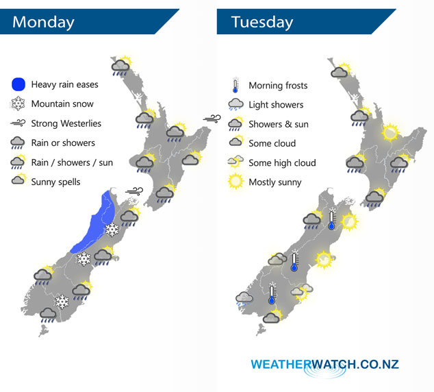
A cold front pushes over the North Island today meanwhile southerlies spread northwards along the South Islands east coast bringing in some wet weather after a dry start. A southwesterly airflow lies over the country on Tuesday.
Showers for much of the western North Island today, perhaps turning to rain for a time around late morning / midday. Drier out east although the Wairarapa sees a few showers / spots of rain. Heavy rain about North Westland eases to showers, cloud and a few showers further south. Showers about Southland and Otago push into Canterbury this afternoon with cool southerlies, expect rain about inland Canterbury by evening with snow lowering to 500m then easing overnight. Snow flurries about the far south to 400m.
Some cloud and a few showers about some North Island regions on Tuesday, expect long periods of dry too especially in the west. Cloudy areas and the risk of a shower for the western South Island, drier and sunnier out east.
By Weather Analyst Aaron Wilkinson – WeatherWatch.co.nz
Comments
Latest Video

Sunday Newsfeed: Low pressure areas increase offshore near northern NZ in days ahead
A light easterly kicks in to the north of the North Island on Sunday as high pressure moves south east…
Related Articles

MetService Auckland rain radar still offline – helicopter called in
Aucklanders may have noticed the rain radar isn’t working. MetService provided us with an update on Friday: “Our technicians quickly…

Monday Newsfeed: Low pressure descending on North Island this week with areas of rain/showers
Wet weather is back in the forecast for some dry parts of New Zealand, mainly north-eastern parts of the North…
Sunday Newsfeed: Low pressure areas increase offshore near northern NZ in days ahead
A light easterly kicks in to the north of the North Island on Sunday as high pressure moves south east…


Add new comment