InfoGraphic: The Big Picture for Monday / Tuesday
11/08/2019 7:00pm

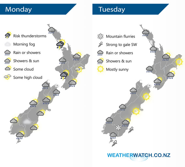
A low pressure system crosses over the country today moving in a west to east fashion, westerly quarter winds for the North Island meanwhile a southerly airflow develops over the South Island. A southwesterly airflow lies over the country on Tuesday, a cold front moves onto the lower South Island in the morning then reaching the western North Island late afternoon / evening.
Showers for much of the western North Island today, heavy at times with a chance of thunderstorms. The Wairarapa is dry then rain / showers moves in around midday. Hawkes Bay and Gisborne have a mainly dry day. Showers Banks Peninsula northwards clear this morning, some rain for Nelson and Marlborough however not clearing till later on. Morning cloud breaks to some sun this morning about the lower South Island, a few light showers move into Southland by midday then Otago late afternoon or evening.
Showers for much of the western North Island again on Tuesday, possibly heavy for a time late afternoon / evening. Mainly dry in the east after any early showers clear. Rain or showers for much of the day along the West Coast of the South Island and about Southland, Otago has a dry start then a few showers move in during the afternoon. Snow flurries lower to low levels (200m) overnight.
By Weather Analyst Aaron Wilkinson – WeatherWatch.co.nz
Comments
Latest Video

ClimateWatch: MAY’s outlook as El Niño ends, NEUTRAL pattern arrives (+Video & 13 Maps)
El Niño may be technically gone but the weather pattern it created is still with our part of the world. By…
Related Articles
ClimateWatch: MAY’s outlook as El Niño ends, NEUTRAL pattern arrives (+Video & 13 Maps)
El Niño may be technically gone but the weather pattern it created is still with our part of the world. By…

Weekend Newsfeed: High pressure starts to grow around NZ, easterlies in the north
The cooler SW flow of this past week is going to fade more going into the weekend as high pressure…

VIDEO: NZ RainWatch -Not much coming next 7 days
High pressure is the main feature driving NZ’s weather for the next 10 days but low pressure is trying to…


Add new comment