InfoGraphic: The Big Picture for Monday / Tuesday
4/02/2018 6:00pm

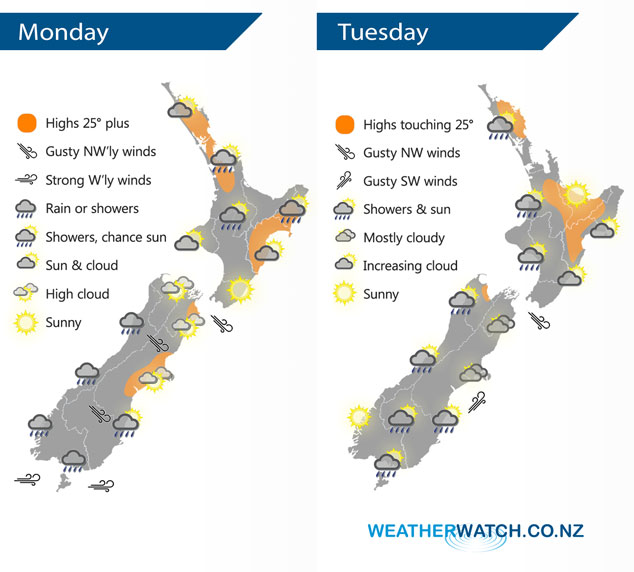
A slack pressure gradient could lead to some unstable weather over the upper North Island today meanwhile a series of fronts push northwards over the South Island during the day. Southwesterlies ease over the country on Tuesday after a windy start for some.
Anywhere from Auckland through to the Central North Island and across to East Cape may be in store for heavy showers this afternoon, perhaps even a thunderstorm then clearing away this evening. Mainly dry elsewhere. The South Island sees rain or showers in the west and south, dry in the east Canterbury northwards although a few showers may sneak into coastal Canterbury later in the evening / overnight Banks Peninsula southwards.
Shower activity clears for most on Tuesday morning however there may be a light shower or two continue through the afternoon and evening about coastal Southland / Otago and along the east coast of the North Island.
By Weather Analyst Aaron Wilkinson – WeatherWatch.co.nz
Comments
Latest Video

Low pressure to cross North Island on Tuesday, rain tracks south tonight, lingers in east (+9 Maps)
Heavy rain is on the way for parts of the North Island, including dry eastern and southern parts. The South…
Related Articles
Low pressure to cross North Island on Tuesday, rain tracks south tonight, lingers in east (+9 Maps)
Heavy rain is on the way for parts of the North Island, including dry eastern and southern parts. The South…

VIDEO: Heavy rain for parts of the North Island Monday/Tuesday as low moves in
Rain is coming into the North Island and brushing some parts of the South Island over the next few days…

Monday Newsfeed: Low pressure descending on North Island this week with areas of rain/showers
Wet weather is back in the forecast for some dry parts of New Zealand, mainly north-eastern parts of the North…


Add new comment