InfoGraphic: The Big Picture for Friday / Saturday
13/02/2020 6:00pm

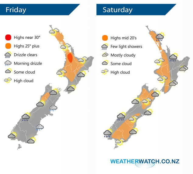
Mainly anticyclonic today, the remnants of a front which moved over the South Island on Thursday brings plenty of cloud to the South Island. A large anticyclone lies to the east of New Zealand on Saturday meanwhile there’s a deep low (ex TC Uesi) in the Tasman Sea, in between a northeasterly airflow flows over the country.
Mostly sunny for the North Island today, expect some high cloud. Cloudy areas push northwards in the east. Cloudy areas for the West Coast of the South Island, the odd light shower or drizzle patch possible this morning. The east coast has the chance of a morning drizzle patch, staying fairly cloudy. Southland and Central Otago does see sun breaking through this afternoon.
Mainly dry across the North Island on Saturday, there may be a light shower or drizzle patch about some northeastern coastlines. Skies in the east are mostly cloudy meanwhile in the west expect high cloud. For the eastern South Island morning cloud breaks to sunny areas and high cloud. Some cloud in the west, risk of a shower about South Westland, more likely overnight.
By Weather Analyst Aaron Wilkinson – WeatherWatch.co.nz
Comments
Latest Video

VIDEO: NZ: Another Autumn change this week as high pressure remains offshore
A low with sub-tropical connections will flirt with the eastern North Island over the next couple of days but the…
Related Articles

Tuesday Newsfeed: A fresh southerly is approaching New Zealand
Today we’re in between systems. For the last day of April it’s not too bad for most. But there’s a…
VIDEO: NZ: Another Autumn change this week as high pressure remains offshore
A low with sub-tropical connections will flirt with the eastern North Island over the next couple of days but the…

Monday Newsfeed: The forecast as we say goodbye to April, hello to May…
In true Autumn style the big picture weatherwise around New Zealand this week is a bit of “everything off the…


Add new comment