InfoGraphic: The Big Picture for Friday / Saturday
23/01/2020 6:00pm

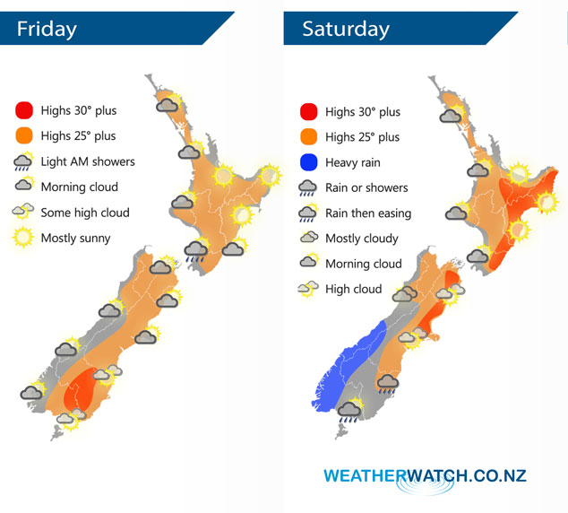
Mainly anticyclonic for New Zealand today bringing more settled weather, still plenty of morning cloud about for some. A front approaches to the west moving onto the lower South Island overnight. A light westerly airflow lies over New Zealand on Saturday, a front within this flow over the lower South Island weakens during the day.
Morning cloud for the western North Island today then breaking to increasing sunny areas from afternoon. Mostly sunny for the eastern North Island. There may be a light morning showers or drizzle patch about Kapiti. Morning cloud breaks for the eastern South Island then expect some high cloud. Sunny spells in the west, the odd shower moves into Fiordland by evening then rain develops there later in the evening / overnight.
Mostly sunny for the North Island on Saturday however expect plenty of morning cloud for western areas. Morning heavy rain for South Westland eases to the odd shower, clearing evening. Mostly sunny in the east with some high cloud. Morning showers for Southland then sun breaks through from afternoon. Otago is mostly cloudy, the odd shower or spit then clearing evening.
By Weather Analyst Aaron Wilkinson – WeatherWatch.co.nz
Comments
Latest Video

VIDEO: NZ RainWatch -Not much coming next 7 days
High pressure is the main feature driving NZ’s weather for the next 10 days but low pressure is trying to…
Related Articles

Weekend Newsfeed: SW flow eases, high pressure starts to grow around NZ
The cooler SW flow of this week is going to fade more going into the weekend as high pressure develops…
VIDEO: NZ RainWatch -Not much coming next 7 days
High pressure is the main feature driving NZ’s weather for the next 10 days but low pressure is trying to…

VIDEO: NZ’s Autumn showers + sub-tropical developments
NZ has a classic Autumn sou-wester today and this eases into Friday and the weekend. Next week low pressure forms…


Add new comment