InfoGraphic: The Big Picture for Friday / Saturday
10/10/2019 6:49pm

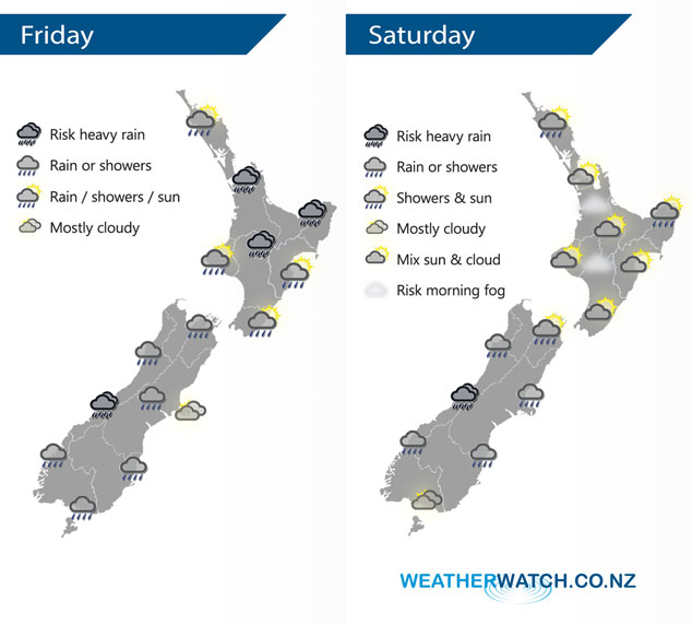
A front marches northeastwards over the North Island during today, two low pressure systems sit either side of the South Island. A slack pressure gradient brings mainly settled conditions to the North Island on Saturday but there could be a few irregularities, low pressure out west draws in a southerly airflow over the South Island.
Rain this morning for the western / northern North Island may be heavy then easing, some sun starts to break through in the west from afternoon. Rain for Bay Of Plenty for most of the day, heavy in the east then easing overnight. Scattered rain develops this morning for the east coast, spreading from the west then clearing in the evening. Areas of rain for the west and south of the South Island, patchy rain or showers about South Canterbury spreads into North Canterbury during the afternoon (more so for inland areas). Marlborough has a mainly dry and sunny day after morning high cloud clears.
A mix of sun and cloud across most of the North Island on Saturday, there could be early mist or fog patches for some inland areas. Showers about East Cape and Northland could become heavy in the afternoon then clearing later in the evening. The odd light morning shower for Wellington then clearing away, an isolated shower or two may make their way into Hawkes Bay and Gisborne from afternoon (mainly about the ranges). Patchy rain or showers for most South Island regions, a mainly dry morning from Banks Peninsula up through to Marlborough. After morning showers Southland becomes dry into the afternoon. Any early heavy rain for the West Coast eases.
By Weather Analyst Aaron Wilkinson – WeatherWatch.co.nz
Comments
Latest Video

ClimateWatch: MAY’s outlook as El Niño ends, NEUTRAL pattern arrives (+Video & 13 Maps)
El Niño may be technically gone but the weather pattern it created is still with our part of the world. By…
Related Articles
ClimateWatch: MAY’s outlook as El Niño ends, NEUTRAL pattern arrives (+Video & 13 Maps)
El Niño may be technically gone but the weather pattern it created is still with our part of the world. By…

Weekend Newsfeed: High pressure starts to grow around NZ, easterlies in the north
The cooler SW flow of this past week is going to fade more going into the weekend as high pressure…

VIDEO: NZ RainWatch -Not much coming next 7 days
High pressure is the main feature driving NZ’s weather for the next 10 days but low pressure is trying to…


Add new comment