Heavy rain may cause isolated flooding, gusty winds continue but ease Thursday (+Maps)
17/01/2018 12:46am

A large but weakening low in the Tasman Sea coupled with a big strong high to our east keeps New Zealand smack bang in the squash zone of windy weather for the next day or two, with heavy rain becoming the main focus now.
While the low is weakening the airflow from the sub-tropics will help generate some very heavy rain later today and on Thursday – coupled with that big blocking high to the east the rain clouds will not be moving through quickly.
It’s this slow sub-tropical set up that could produce areas of localised flooding, especially in areas like Nelson, Taranaki, potentially Manawatu and potentially Northland.
WINDS
Peaking today in most regions, with the northern North Island most exposed to the strongest gusts. The NE flow today tilts more N on Thursday and winds start to unwind, easing further on Friday with light or lighter winds for many.
RAIN:
WEDNESDAY:
Heavy rain today in the South Island’s south west and north west corners with the Nelson area especially likely to have heavy set in rain across Wednesday PM, easing Thursday AM. Flooding and slips possible, rivers may also rapidly rise so campers in low lying areas need to have a plan in case they are in a vulnerable area.
THURSDAY:
Now the rain band, heavy and sub-tropical, moves into the North Island with heavy falls in the west. Heaviest rain, similar to what Nelson may get today, will be in the Mt Taranaki area and potentially the ranges of the lower North Island and Manawatu area.
Across Thursday and into the afternoon and evening that slow band of heavy sub-tropical fuelled rain will move through Northland and Auckland.
There’s also a chance of heavy rain, or downpours, around parts of Southland and Otago as a southerly change moves through there – good news for those desperate for soaking rains.
FRIDAY:
Humid in northern New Zealand with the chance of isolated downpours, may be drizzle patches and showers scattered in other parts of New Zealand.
WEEKEND:
Humid sub-tropical north to north east winds continue in the upper North Island bringing further heavy downpours, which may also affect some eastern parts of the South Island. The weekend is still looking uncertain about where exactly the wet weather will be – but the humid sub-tropical airflow will be continuing on.
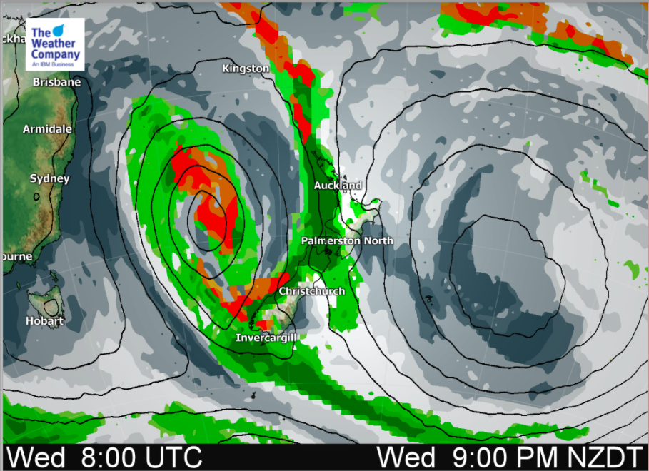 Key: Light green = showers, drizzle. Dark green = Rain or heavy downpours. Red/Brown = Isolated thunderstorms.
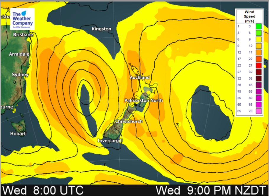 A weakening low to the west of New Zealand and a very big strong high to the east of New Zealand. The ‘squash zone’ with the windiest weather is between these two systems across the upper North Island.
Wind Key for map above: Yellow = 22km/h to 32km/h. Orange = 32 to 61km/h (gale force is 61km/h+). Winds ease on Thursday.
– Maps by The Weather Company
– WeatherWatch.co.nz (an official IBM business partner)
Comments
Latest Video

VIDEO: RainWatch – Will a northern low bring rain next week?
High pressure has been dominating NZ for almost two weeks now but next week there is the chance of some…
Related Articles

Weekend Newsfeed: Aurora possible again tonight for some, High pressure moves in by Monday (+6 Maps)
Colder airflows will fade this weekend but the nights will still be colder due to lighter winds and high pressure…
VIDEO: RainWatch – Will a northern low bring rain next week?
High pressure has been dominating NZ for almost two weeks now but next week there is the chance of some…

The solar winter has begun… the 3 darkest months of the year
While we’re still in Autumn the “Solar Winter” has just begun – the second week of May marks the three…


Add new comment