
A few days ago a large high was lying west of New Zealand dredging up cold southerlies – this weekend that high is pressing in across the country calming things down, drying and clearing out the skies, and briefly locking in the cold air it just brought in (before flushing that air away with warmer winds developing Sunday and Monday).
It’s not settled everywhere as we head into Saturday evening with strong winds and rain/showers at times around Gisborne as the last of the southerly blast moves through our most eastern regions. Northern Hawke’s Bay is also caught up in the windy, showery, cold southerly with sleety showers inland into the ranges, turning to snow showers on the summits.
Overnight and into Sunday the high rolls in – and frosts develop for the coldest most sheltered coldest areas, especially the South Island.
Frosts are likely in both islands overnight – check the 1500 forecasts we have to see expected low temperatures in your area overnight, because using just the main centre forecasts may not be localised enough. Generally 3 or 4 degrees and below has frost risk if skies are clear and winds die out, as temperatures in some sheltered areas may drop another degree or two beyond that even. See the temperature map below for more guidance too.
With some wind and/or cloud remaining in a number of North Island regions any light frost will be borderline or unlikely. The air movement and cloudy areas lie on the outer edges of the high, so these places may have a cold night but not quite frosty – others may have a light frost develop further inland or at higher elevations.
Hopefully for most growers it won’t be too much of a headache with frosts further north unlikely to be too widespread of heavy, or reach much above ground level… but no doubt you’ll be monitoring closely this evening and Sunday morning, just to make sure.
Some eastern parts of the North Island may also have a slight frost risk on Monday morning – but a westerly flow is developing next week bringing mild weather again to most regions.
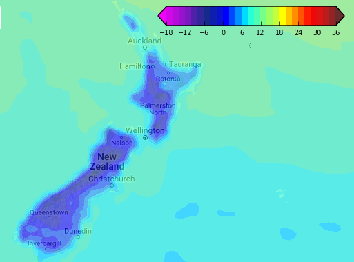 – Image / Dawn Sunday temperature map shows a big portion of New Zealand dropping down towards zero degrees, or below. Warmer weather returns Sunday afternoon and next week / See more temperature maps here, data courtesy Weathermap.
– WeatherWatch.co.nz
Comments
Latest Video

Sunday Newsfeed: Low pressure areas increase offshore near northern NZ in days ahead
A light easterly kicks in to the north of the North Island on Sunday as high pressure moves south east…
Related Articles
Sunday Newsfeed: Low pressure areas increase offshore near northern NZ in days ahead
A light easterly kicks in to the north of the North Island on Sunday as high pressure moves south east…

VIDEO: 7 Day NZ RainWatch: Who gets rain, who misses out
A cold front will bring winter-like weather into the lower South Island on Saturday but won’t make to the top…

VIDEO: Wintry weather in the south, showers continue in the north
Saturday will feel like winter in the lower South Island but northerners will be under high pressure and lighter winds….


Add new comment