Damaging winds possible along Australia’s southern coastline, weakens but reaches NZ this Tues/Weds
4/08/2018 7:00pm

A considerably large low covers the Southern Ocean south of Australia and will bring strong winds across southern coastal Australia for the next few days ahead. The main front system moves through Sunday morning and Monday, then weakens somewhat as it crosses the Tasman Sea towards New Zealand on Tuesday and Wednesday.
Periods of intense showery rain is expected along the southern coast from South Australia to western Victoria from Sunday morning through Monday. Thunderstorms are possible because the upper level cold surge makes the air quite unstable.
Strong persistent winds are expected over the area near and behind the front on Sunday and Monday in Australia. Winds exceeding 50 km/h or even gale force (63 km/h) are possible.
This system loses a bit of energy as it moves towards New Zealand but will still bring a burst of heavy rain with possible thunderstorms in the west and a surge of strong nor’westers around Tuesday and Wednesday. It will also kick off a trend of westerlies for a number of days ahead bringing more rain to the west, dry weather to the east and temperatures above average for many regions.
The map below for 6pm Tuesday (showing NZ as well) shows the large belt of westerlies moving in from Australia with high pressure east of New Zealand moving away eastwards. A high moving into Australia next week will encourage these westerlies which are likely to lift temperatures in New Zealand above average.


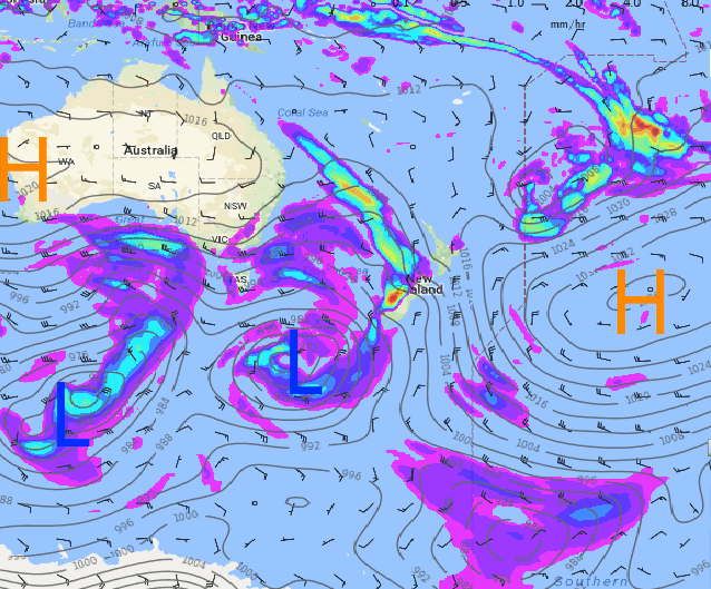 – 6pm Tuesday / Weathermap.co.nz
– WeatherWatch.co.nz
Comments
Latest Video

ClimateWatch: MAY’s outlook as El Niño ends, NEUTRAL pattern arrives (+Video & 13 Maps)
El Niño may be technically gone but the weather pattern it created is still with our part of the world. By…
Related Articles
ClimateWatch: MAY’s outlook as El Niño ends, NEUTRAL pattern arrives (+Video & 13 Maps)
El Niño may be technically gone but the weather pattern it created is still with our part of the world. By…

Weekend Newsfeed: High pressure starts to grow around NZ, easterlies in the north
The cooler SW flow of this past week is going to fade more going into the weekend as high pressure…

VIDEO: NZ RainWatch -Not much coming next 7 days
High pressure is the main feature driving NZ’s weather for the next 10 days but low pressure is trying to…


Add new comment