
By 7:30 on Monday morning it was already in the mid 30s in parts of Sydney. Today it’s nearly 20 degrees cooler at the same time thanks to the “Southerly Buster” that moved through late Monday.
The colder air flow is due to a southerly from the Southern Ocean spreading into the southeast part of Australia and is affecting a number of major cities.
While it’s cooler in NSW today it will be mostly sunny, while Victoria will become cloudy by afternoon.
Maximum and Minimum temperature will be both significantly lower than normal on Tuesday across most areas in NSW, VIC, and SA.
Departure from normal will be mostly over 4C and even reach 8C cooler than normal in some inland areas.
This cool trend is however alleviated to some extent along the east coast, where the cold southerly wind is blocked by the Great Dividing Range. Min temperatures on Tuesday night is close to normal in coastal areas of Victoria thanks to cloud cover.
The area of cool weather will migrate northwestward on Wednesday, leaving Victoria and southern NSW with normal temperatures.


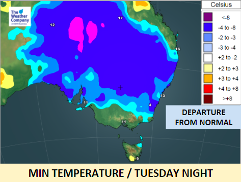
– Maps / The Weather Company (an official WeatherWatch partner)
– WeatherWatch.co.nz
Comments
Latest Video

VIDEO: Anzac Day + weather to next Tuesday
Anzac Day looks mild for many parts of NZ with windy nor’westers gusting to gale force for some. Many regions…
Related Articles

VIDEO: Australia-only 7 Day: Wet easterly vs cold southerly
Wet weather and windy easterlies for eastern Australia along with colder southerlies in the south makes for some changeable weather…

El Niño officially comes to an end, what does neutral mean weather-wise?
El Niño has come to an official end, according to scientists at the Bureau of Meteorology – the climate experts…

VIDEO: NEW: Australia – Your week ahead weatherwise
In this NEW Monday feature, we’re trialling in April a shorter video outlining the Big Picture for Australia. We’ll cover…


Add new comment