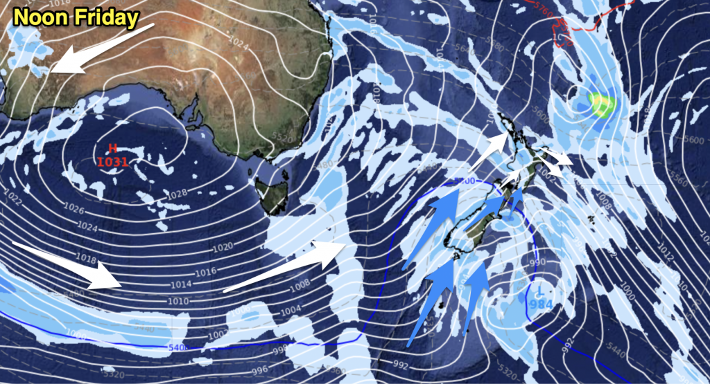
A ridge lies over the upper North Island today, the ridge connects to areas of high pressure, one to the east of the North Island a fair way offshore, then the other to the west of the North Island in the Tasman Sea. The rest of the country is covered by a gusty northwesterly airflow.
Northland, Auckland, Waikato & Bay Of Plenty
A few clouds drifting about but plenty of sun also, sun more likely Auckland northwards with the Waikato and Bay Of Plenty seeing slighter more frequent areas of cloud especially in the morning. Light winds in the morning tending onshore in the afternoon, afternoon westerlies for the Waikato.
Highs: 25-27
Western North Island (including Central North Island)
Sunny areas after morning cloud breaks up a little, west to northwesterly breezes.
Highs: 22-24
Eastern North Island
A mainly sunny day on the way after any early cloud clears, light winds then afternoon east to northeast breezes near the coast.
Highs: 25-27
Wellington
Sunny areas with brisk Northerly winds.
High: 22
Marlborough & Nelson
Mostly sunny with a touch of high cloud at times, Northerly winds.
Highs: 26-30
Canterbury
Mostly sunny with some high cloud, North to Nor’West winds breezy at times especially inland.
Highs: 28-30
West Coast
Cloudy with areas of rain about South Westland, becoming heavy there overnight. The odd shower further north through to about Greymouth. Winds from the west or northwest.
Highs: 20-22
Southland & Otago
Plenty of high cloud, a few spots of rain later in the evening. Winds gusty from the northwest inland, a bit lighter near the coast. Winds changing southwest overnight with showers moving into Southland.
Highs: 23-26
By Weather Analyst Aaron Wilkinson – WeatherWatch.co.nz


Add new comment