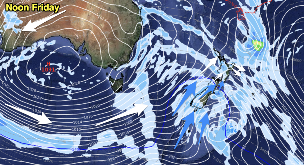
A ridge keeps conditions fairly calm this morning however this changes afternoon as a front and low combination starts to move in from the Tasman Sea. It moves over evening and many areas will see some rain, heavy and thundery in the west of both island’s north of about Greymouth. In the east of both islands as the front passes over it may only produce a brief period of rain.
Central North Island, Waikato, Auckland & Northland
Sunny and cloudy spells with west to northwest breezes, chance of the odd shower along some western coastlines otherwise mainly dry. Cloud thickens up midday onwards, in the evening a period of heavy thundery rain moves through easing to showers around midnight with a westerly change. As these thunderstorms move through there is the low risk of an isolated tornado.
Highs: 13-17
Bay Of Plenty
Sunny spells and some cloud with breezy westerlies. Cloud thickens up late afternoon then some rain moves through in the evening for a time which could be heavy and thundery, clearing around midnight with westerly change.
High: 17
Eastern North Island
Any early cloud clears to a mostly sunny day, westerly breezes in the morning die out. High cloud thickens late afternoon onwards, there is the low risk of a late spot of rain in the evening.
Highs: 16-17
Western North Island
Cloudy spells with the odd shower, mainly dry however. Expect west to northwest winds. Cloud thickens from afternoon with winds tending more northerly. Rain with thunderstorms (and the low risk of a tornado) develops about Taranaki late afternoon, rain spreads further south during the evening.
Highs: 15-16
Wellington
Morning sunny spells however cloud increases in the afternoon with northerly breezes stengthening. A period of rain moves through in the evening then clears around midnight.
High: 13
Nelson
Sunny spells and increasing cloud, north to northwesterly winds. A period of rain moves through from late afternoon then clears by late evening as winds change westerly.
Highs: 14-15
Marlborough
Sunny with thickening high cloud, north to northwesterly winds become a little breezy later in the afternoon. A few brief spots of rain move through during the evening.
High: 16
Canterbury
Sunny spells to start in the morning, high cloud then start to thicken from late morning. In the evening a few spots of rain move through from the west. About the foothills and western ranges of Canterbury this may be a period of rain for a time rather then just a few spots. Northeasterly breezes.
Highs: 14-15
West Coast
Skies becoming cloudy in the morning, rain develops in the afternoon with a few heavy thundery falls possible, especially north of about Greymouth. Rain eases to showers late evening with northerlies changing westerly.
Highs: 13-14
Southland & Otago
Sunny spells at first in the morning however high cloud quickly thickens with skies becoming mostly cloudy in the afternoon. Expect east to northeast breezes. Patchy rain moves into Otago mid afternoon and Southland by evening.
Highs: 10-12
WeatherWatch.co.nz


Add new comment