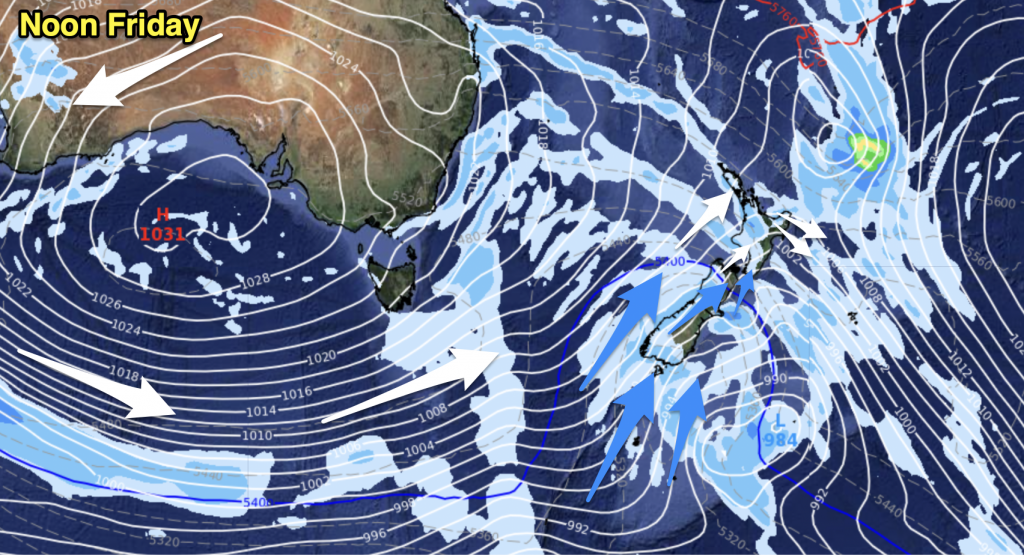
A west to southwesterly airflow lies over the country today, showers in the west of both islands and also about the far south of the South Island. Dry weather for the east of the South Island at first although a front does move north during the day bringing a few showers.
Auckland & Northland
Periods of cloud and sunny spells at times with breezy northwesterlies. Winds tend more westerly late afternoon becoming gusty with the odd shower moving in too.
Highs: 18-20
Bay Of Plenty
Early rain clears then sunny spells develop, northwesterlies. Mid afternoon
till evening the odd shower may move in again from the west as northwesterlies
tend more westerly.
till evening the odd shower may move in again from the west as northwesterlies
tend more westerly.
High: 18
Waikato & Central North Island
Cloudy periods with showers at times, dry spells too. Northwesterlies tend
more westerly in the afternoon then freshen. Showers mostly clear in the evening
although some may remain about southern parts of the Central North Island.
more westerly in the afternoon then freshen. Showers mostly clear in the evening
although some may remain about southern parts of the Central North Island.
Highs: 14-17
Eastern North Island
Mostly sunny with light winds in the morning, afternoon
northwesterlies.
northwesterlies.
Highs: 19-20
Western North Island
Periods of cloud with breezy northwesterlies, tending more westerly in the
afternoon. The odd shower at times.
afternoon. The odd shower at times.
High: 16
Wellington
Cloudy periods in the morning with gusty northerlies, a few showers move
through around midday. Sunny spells increase in the afternoon after showers
clear, overnight winds change southerly with increasing cloud and showers
towards dawn.
through around midday. Sunny spells increase in the afternoon after showers
clear, overnight winds change southerly with increasing cloud and showers
towards dawn.
High: 15
Nelson
Periods of cloud with the odd brief shower possible otherwise mainly dry,
breezy northwesterlies.
breezy northwesterlies.
High: 15
Marlborough
Mostly sunny with breezy northwesterlies, winds change southerly overnight
with some cloud, perhaps a shower or two moving into southern Marlborough and
about the coast south of Clifford Bay.
with some cloud, perhaps a shower or two moving into southern Marlborough and
about the coast south of Clifford Bay.
Highs: 17-18
Canterbury
Sunny areas and some high cloud with northerly winds in the morning, mid
afternoon southwesterlies move in bringing increasing cloud. Chance of a shower
with the change although there is a greater risk or showers later in the
evening.
afternoon southwesterlies move in bringing increasing cloud. Chance of a shower
with the change although there is a greater risk or showers later in the
evening.
Highs: 16-17
West Coast
Rain with heavy falls at times in the morning, northwesterlies. A change to
southwesterlies in the afternoon with rain easing to showers.
southwesterlies in the afternoon with rain easing to showers.
Highs 13-14
Coastal Otago
High cloud increases in the morning with light winds, a gusty southwest
change early afternoon brings a period of showers which clear by evening. Winds
ease overnight.
change early afternoon brings a period of showers which clear by evening. Winds
ease overnight.
High: 13
Central Otago
Sunny areas and high cloud with light winds in the morning, a midday
southwest change brings a period of showers which clear by evening. Cold
overnight with mainly clear skies.
southwest change brings a period of showers which clear by evening. Cold
overnight with mainly clear skies.
Highs: 9-11
Southland
Increasing cloud with light northerlies at first, rain from mid morning
then easing to showers around midday with a southwest change. Showers ease in
the evening then clear later.
then easing to showers around midday with a southwest change. Showers ease in
the evening then clear later.
High: 11
By Weather Analyst Aaron Wilkinson – WeatherWatch.co.nz


Add new comment