Sub-tropical low grazing northern NZ with some rain + eastern Australia unsettled (+9 Maps)
17/11/2017 8:31pm

A large sub-tropical low is today brushing past the upper North Island of New Zealand and is bringing patchy rain to the eastern side of Northland and around Auckland’s Great Barrier Island. A few light spits are also falling over northern Coromandel Peninsula.
Today the low will continue to lie north of northern New Zealand and a few spits are possible in Auckland City and even into some parts of Bay of Plenty as the low tracks to the south east slowly.
The main rain band will mainly brush eastern Northland and East Cape.
Meanwhile parts of eastern Australia will be kicking of several days of wet weather from this weekend – the same time that New Zealand is entering into a longer dry spell. Australians in the east can expect more thunderstorms, large hail, downpours and gloomy days in the week ahead.


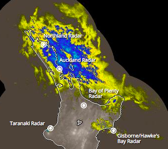 – 9:20am upper North Island Rain Radars show the low brushing eastern Northland, and also bringing some drizzle into Northern Hawke’s Bay and up towards Gisborne and East Cape. -Rain Radar and images 100% owned by the NZ Government / funded by the NZ Taxpayer.
– WeatherWatch.co.nz
Comments
Latest Video

VIDEO: Anzac Day + weather to next Tuesday
Anzac Day looks mild for many parts of NZ with windy nor’westers gusting to gale force for some. Many regions…
Related Articles

Anzac Day Newsfeed: Severe gales, heavy rain for some, settled for others
Updated 4am — High pressure over northern NZ moves east of the country on Thursday while a storm south of…
VIDEO: Anzac Day + weather to next Tuesday
Anzac Day looks mild for many parts of NZ with windy nor’westers gusting to gale force for some. Many regions…

Wednesday Newsfeed: Westerlies strengthen today, windier Anzac Day tomorrow
High pressure crosses over the top of the North Island on Wednesday allowing for westerlies to build further south. As…


Add new comment