Saturday PM: Heavy downpour and thunderstorm risk again inland – both islands
26/01/2018 6:35pm

There’s no real change in the forecast this weekend with morning cloud and isolated afternoon cloud build ups that could produce heavy downpours and thunderstorms, some severe.
Yesterday a thunderstorm outbreak rapidly developed in eastern Bay of Plenty then dramatically tracked towards Rotorua and Tauranga and the Kaimai Ranges will others tracked across Waikato including Cambridge and Hamilton.
Slight shifts in wind directions today means they will likely form in slightly different areas.
Highest risk areas are the areas of ‘blue blobs’ in the map below and mid to late afternoon is usually when they develop, easing by evening.
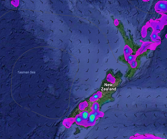
– Image / 4pm Saturday, Weathermap.co.nz
– WeatherWatch.co.nz
Comments
Latest Video

VIDEO: Anzac Day + weather to next Tuesday
Anzac Day looks mild for many parts of NZ with windy nor’westers gusting to gale force for some. Many regions…
Related Articles

Anzac Day Newsfeed: Strong winds for some, settled for others
High pressure over northern NZ moves east of the country on Thursday while a storm south of NZ works with…
VIDEO: Anzac Day + weather to next Tuesday
Anzac Day looks mild for many parts of NZ with windy nor’westers gusting to gale force for some. Many regions…

Wednesday Newsfeed: Westerlies strengthen today, windier Anzac Day tomorrow
High pressure crosses over the top of the North Island on Wednesday allowing for westerlies to build further south. As…


Add new comment