
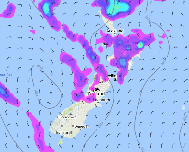
A light northerly airflow lies over New Zealand today, flowing around a large high centered well east of New Zealand in the Pacific Ocean.
Most parts of the North Island have the chance of a shower today, but there will be many dry areas also. The chance of showers increases for inland areas during the afternoon / evening where heating and converging winds could lead to heavy downpours and possibly even thunderstorms. Showers ease later this evening. I would try to be more specific but the nature of these showers is often quite random and hard to narrow down too much.
Most of the South Island is dry this morning, just the chance of a light shower for North Westland and parts of Nelson / Marlborough. This afternoon the shower risk increases for inland areas north of about South Canterbury, showers will be quite isolated in nature so many parts may remain dry. But for areas that do see showers there is the risk of a downpour and perhaps even a thunderstorm. Showers activity clears later in the day / overnight.
WeatherWatch.co.nz
Image – Tuesday 02nd January 1pm MSLP / Rain map – weathermap.co.nz
Comments
Latest Video

VIDEO: RainWatch: Northern rain, then powerful high next week, but more rain next weekend?
A weak area of low pressure will move across the upper North Island this weekend and bring more welcome rain…
Related Articles

Weekend Newsfeed: Northern low. High pressure returning.
We’ve got a few moving parts to our weather over the weekend – but plenty of dry weather around too….
VIDEO: RainWatch: Northern rain, then powerful high next week, but more rain next weekend?
A weak area of low pressure will move across the upper North Island this weekend and bring more welcome rain…

VIDEO: A weak low for NZ on Saturday, high pressure next week
A low will move over the North Island on Saturday and fall apart – bringing patchy rain and showers across…


Add new comment