
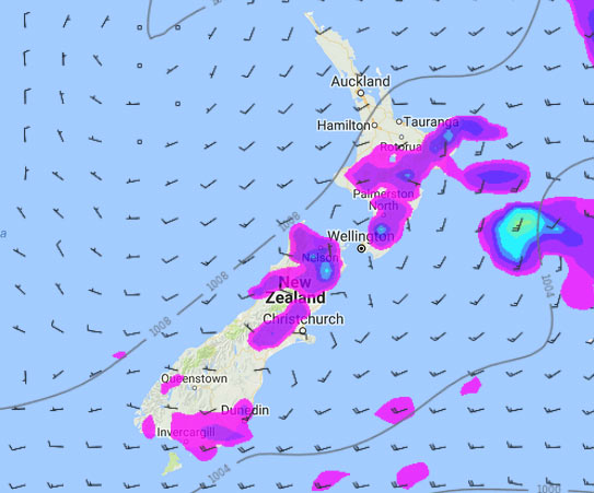
A southwesterly airflow lies over New Zealand today, easing later on as a ridge moves in.
RainWatch is a series during the weekdays, giving a snapshot about where around New Zealand areas of precipitation may affect your day – This is the last RainWatch we will be issuing till late December 2017.
Morning showers possibly heavy about the upper North Island then easing and becoming few and far between into the afternoon.
About the lower North Island, heavy showers this morning in the west and across to the Wairarapa with a chance of hail and thunderstorms then easing this afternoon. Wairarapa through to Gisborne about the ranges may see isolated showers pop up this afternoon then clearing in the evening.
Early heavy showers ease about Marlborough and Nelson then a few sunny areas break through. An isolated shower or two may pop up in the afternoon about the upper South Island then clearing away in the evening. Showers mainly inland.
Southland and Otago see the odd shower about coastal areas, clearing in the evening.
WeatherWatch.co.nz
Image – Friday 4pm, 20th January 2017 rain / MSLP map – weathermap.co.nz
Comments
Latest Video

VIDEO: NZ’s Anzac Day forecast + this weekend too
High pressure may be moving over northern NZ but it will help create a windier westerly across the country which…
Related Articles
VIDEO: NZ’s Anzac Day forecast + this weekend too
High pressure may be moving over northern NZ but it will help create a windier westerly across the country which…

Tuesday Newsfeed: High pressure increases, westerlies do too
High pressure is drifting towards the North Island and the more it moves in the more it pushes away the…

VIDEO: NZ – Unsettled at times this week as highs & lows move by
High pressure is quickly crossing the North Island this week meaning some break in the wet weather but it may…


Add new comment