
A low pressure system centred just west of the South Island in the Tasman Sea continues to churn away today feeding a front into the upper South Island.
For the North Island it’s still yet another mainly dry day, there is the risk of an isolated shower late afternoon / evening about some inland parts of the upper North Island however it’s looking mainly dry overall.
The Wairarapa and perhaps Wellington may see a light shower or drizzle patch this morning then mainly dry. The ranges running behind Wairarapa through to Gisborne see showers develop this afternoon, some may become heavy with thunderstorms and even spread to coastal parts this evening then easing later on or overnight.
The upper South Island sees rain or showers for most regions, Nelson and Marlborough should see dry areas from afternoon. Canterbury, especially in central areas sees rain which is fairly persistent then easing from afternoon, rain for inland areas may even be heavy at times. The West Coast sees areas of rain today, once again heavy at times especially about the main divide.
Otago, Southland and over in Fiordland is mainly dry today. On the West Coast as you head northwards towards the Glaciers rain will start to set in.
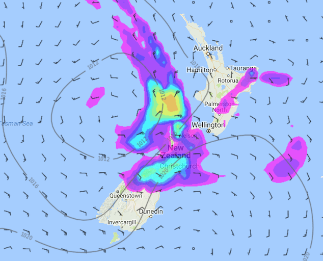
Image – Friday 12th January 2018 1pm MSLP / Rain map – weathermap.co.nz
WeatherWatch.co.nz
Comments
Latest Video

VIDEO: RainWatch: Northern rain, then powerful high next week, but more rain next weekend?
A weak area of low pressure will move across the upper North Island this weekend and bring more welcome rain…
Related Articles

Weekend Newsfeed: High pressure returning. Some fog patches possible.
High pressure is moving into the country and pushing away the North Island low. As a result of light winds,…
VIDEO: RainWatch: Northern rain, then powerful high next week, but more rain next weekend?
A weak area of low pressure will move across the upper North Island this weekend and bring more welcome rain…

VIDEO: A weak low for NZ on Saturday, high pressure next week
A low will move over the North Island on Saturday and fall apart – bringing patchy rain and showers across…


Add new comment