
Another burst of heavy rain and snow (similar to what we’ve seen over Tuesday and today) is coming again from late Thursday and across Friday over New Zealand.
The secondary blast is a more complicated one and may linger longer with the colder south to south west change behind it (ie, colder air lasting all weekend) however the rain and snow component is fairly straight forward and will push up the South Island across Thursday with the coldest air coming in at night and over Friday and the snow level lowering.
This cold front will reach the North Island on Thursday evening with isolated thunderstorms, then heavy rain and squally showers continue along the western side of the North Island on Friday. (The maps below don’t capture rain or snow after 7pm Thurs, we hope to bring that update to you tomorrow).
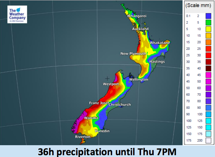
Here’s the latest outlook for rain and snow until Thursday evening across New Zealand:

– WeatherWatch.co.nz (An official IBM/TWC business partner)
Comments
Latest Video

VIDEO: A weak low for NZ on Saturday, high pressure next week
A low will move over the North Island on Saturday and fall apart – bringing patchy rain and showers across…
Related Articles
VIDEO: A weak low for NZ on Saturday, high pressure next week
A low will move over the North Island on Saturday and fall apart – bringing patchy rain and showers across…

El Niño officially comes to an end, what does neutral mean weather-wise?
El Niño has come to an official end, according to scientists at the Bureau of Meteorology – the climate experts…

Thursday: Mainly dry today but northern low pressure for Saturday
Thursday has high pressure parked over Cape Reinga, Friday has another cold front in the south and Saturday has new…


Add new comment