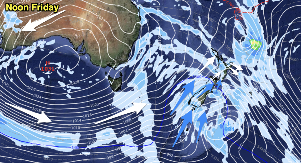
A front moves northwards over the South Island this morning and afternoon then onto the North Island this evening. Heavy rain in the west with thunderstorms for some. Winds ahead of the front are mostly strong from the northwest then changing west to southwest behind it. The east coast is fairly dry, however a strong southerly change moves onto the lower South Island this afternoon then Canterbury in the evening bringing rain.
Northland, Auckland, Waikato & Bay Of Plenty
Cloudy areas with the chance of a shower. Heavy showers with possible thunderstorms in the evening as northwesterly winds change gusty southwest.
Highs: 20-22
Western North Island (including Central North Island)
A few showers about Taranaki from morning, increasing cloud elsewhere. Late afternoon or evening rain develops, becoming heavy with a risk of thunderstorms. Gusty northwesterlies change southwest overnight.
Highs: 17-20
Eastern North Island
Mostly sunny with high cloud increasing from afternoon. Northwesterly winds becoming gusty after midday, strong about the Wairarapa. Spots of rain develop about the Wairarapa in the evening then spreading northwards, winds change southwest overnight with a few showers.
Highs: 22-23
Wellington
Increasing cloud, the odd shower from afternoon then evening rain, possibly heavy with thunderstorms. Strong to gale northwesterly winds change strong to gale southerly overnight.
High: 17
Marlborough & Nelson
Increasing cloud, north to northwesterly winds rising to gale in the afternoon. Showers from afternoon about Nelson, then rain passes over late afternoon / evening. Rain may be heavy with a chance of thunderstorms for Nelson. Winds change gusty southwest overnight.
Highs: 18-20
Canterbury
Sunny areas and increasing high cloud, areas of rain about and west of the foothills during the day, heavy falls in the high country with possible thunderstorms. Winds becoming strong from the northwest in the afternoon, a chance of gales, mainly inland. In the evening, a strong southwest change develops bringing rain, winds rising to gale about the coast and Banks Peninsula. A chance of thunderstorms about Banks Peninsula in the evening with the change.
Highs: 20-21
West Coast
Rain, heavy falls from afternoon, with thunderstorms and hail as gusty northwesterly winds change southwest. Rain clears overnight.
Highs: 14-15
Southland & Otago
High cloud with northwesterly winds, rain develops early to mid afternoon with a strong southwest change. Rain may be heavy for a time with a risk of hail and some snow to 600m.
Highs: 13-14
By Weather Analyst Aaron Wilkinson – WeatherWatch.co.nz


Add new comment