Full details about how Cyclone Hola may impact New Zealand across Monday (+12 Maps)
11/03/2018 7:30am

EXTENSIVE UPDATE — UPDATED 5:30am Monday NZDT — Tropical Cyclone Hola continues to track quickly towards New Zealand and will bring wind and rain across Monday before departing in the early hours of Tuesday morning.
As of 5:30am Monday Hola was estimated to have sustained winds of around 80km/h with gusts to 100km/h. The centre should be a few hundred kilometres north of NZ.
 – The sun setting on Sunday over New Zealand Sunday evening with Cyclone Gita spreading cloud over the northern half of the North Island. Image / JMA
@WeatherWatchNZ could this be the very southern edge of Cyclone Hola in Hawkes Bay? Or am I too early? pic.twitter.com/ybZn6j9N7L
— Alison Francis (@TheBalali) March 11, 2018
Hola has today begun the transition from a “tropical” cyclone (with a warm core) to an “extra-tropical” cyclone (with a cold core). While on the ground you don’t notice this the storm structure does change a lot – with the centre becoming stretched out and elongated in the New Zealand area, this spreads energy further afield and can reduce peak winds.
Hola has a small but very potent burst of rain with it. Best estimates is that this torrential rain will brush Northland, potentially Coromandel Peninsula but could be most intense though Bay of Plenty and into the Gisborne and northern Hawke’s Bay ranges. This rain may cause flooding and slips in these areas and affect State Highways.
Winds associated with this cyclone will change a lot due to the centre of the low morphing into a new system. Wind damage may be in certain areas rather than widespread, with various wind tunnels being one factor and the other factor being the damaging winds right at the centre of the low – but these winds will only cause damage near the centre, so if the centre remains out at sea so too will the worst winds.
WILL HOLA MAKE LANDFALL IN NZ?
When Gita and Fehi formed the chances of them making landfall based on long range modelling from various forecasters was easy – the storms both had high chances, in our view, of landfall due to the western approach. This storm is coming in from the north and is tracking south east – which means it runs parallel to a line that runs from Northland to Coromandel Peninsula towards East Cape. Some models show it could come very close to Northland on Monday morning, but most agree East Cape has the highest chance of the centre coming in. Believe it or not, despite being just a day out, we still need more time to fine tune this. Once the storm is within a couple of hundred kilometres it will be easier to work out – and will start to appear on public rain radar too. Hola is now less than 1000kms north of Auckland.
At the moment a direct landfall in New Zealand (when the very centre crosses land) looks less likely – but is very close in the current modelling.
What two reliable models are saying about potential New Zealand landfall: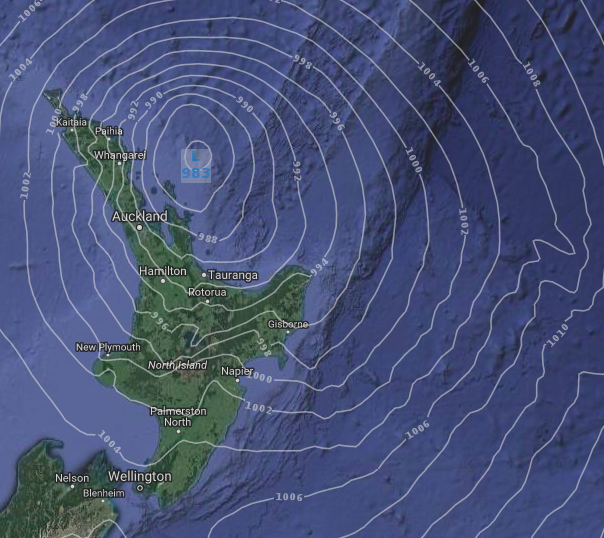
ABOVE – ECMWF (European model) for 6pm Monday shows the centre of Hola close to eastern Northland – but not tracking any closer.
BELOW – GFS (American model) for 9pm Monday shows the centre of Hola very near East Cape. If GFS shifts the tracking just a little more westwards (as it’s been doing for the past few days) it means a direct hit is more likely in eastern BOP or East Cape. We’ll have more details on Monday about any potential landfall but for now the modelling mostly suggests the centre may remain just offshore. This could change – we’ll be tracking very closely on Monday in case it drifts closer to land (Making the weather more extreme) or further east to sea (easing conditions further here in NZ).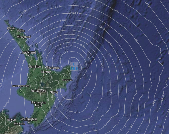
RAIN
Cyclone Hola wants to naturally track just east of the North Island but a strong south east wind flow that it’s running in to may guide the low closer to New Zealand – or at least push the heaviest rain back in.
Regions most exposed to localised flooding rains are: Eastern Northland, Coromandel Peninsula, Eastern BOP, East Cape, Gisborne (inland) and the northern Hawke’s Bay Ranges.
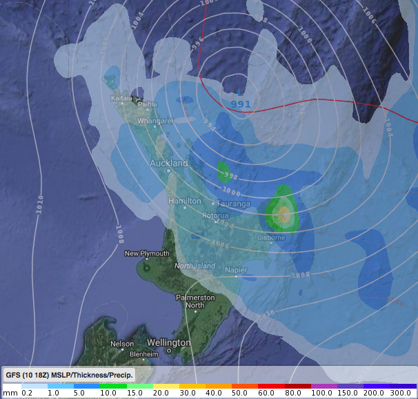
Below are the 3pm Rain Maps for Monday – comparing ECMWF and GFS (note they show a similar forecast)
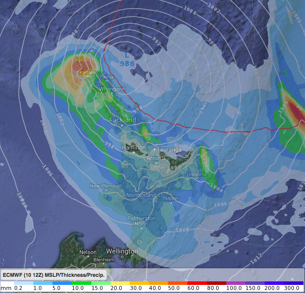
ABOVE – ECMWF
BELOW – GFS
Hola is transitioning into an extra-tropical cyclone. One of the most obvious ways to see this in a rain map is when the rain clouds go from being all the way around the centre to being just in the southern half of the low. This is what we’re seeing on Monday PM as the low really moves in and the centre changes shape and stretches out as it’s flooded with cooler air and the system changes.
Some of the heaviest rain could be in the afternoon and evening through Bay of Plenty (mainly central and eastern) and then into the eastern ranges from East Cape to Gisborne to Northern Hawke’s Bay (with the bulk of the rain coming in from the north). This may still shift around a bit by 100 or 150kms so not 100% locked in, but it’s the best thinking today based on a number of models.
Here’s the 7pm Monday rain map (by GFS – the same ones you get at WeatherWatch.co.nz in the ‘Maps’ tab)
WIND
It’s very complicated working out the winds if the centre of the low only brushes New Zealand. Unlike a “normal” low that we often get in NZ an ex-cyclone has the worst weather just at the centre. Once you get more than 200 or 300kms away from the centre you’re really outside the risk zone for severe weather. If Hola remains at sea it means northern New Zealand will be brushed by the damaging winds from a few directions. But if Hola makes a direct hit some places could have winds blowing from all directions (eg, may start as a northerly, then turn easterly, then southerly, then end west to south west). When this happens it can be very hard to pin point which wind tunnels and ranges are going to fuel stronger winds due to the complicated terrain here.
At this stage regions most exposed to damaging winds (Ie, power cuts, trees down, perhaps some lower end structural damage like broken windows, lifting some roofing iron and damaging old weak sheds, barns etc) will be: Northland, parts of Auckland, eastern Waikato, and potentially into Bay of Plenty and East Cape too.
Remember, Hola is now turning into a new low pressure system – just like we saw with Cyclone Gita the centre of the low can dramatically change shape and that means damaging winds can vanish quite quickly during this process… and this process occurs on Monday over northern NZ.
The wind maps below are from ECMWF (Which is currently showing a closer track to NZ than GFS). These maps cover wind GUSTS.
MIDNIGHT SUNDAY (Tonight)

NOON MONDAY: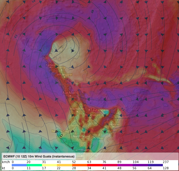
MIDNIGHT MONDAY: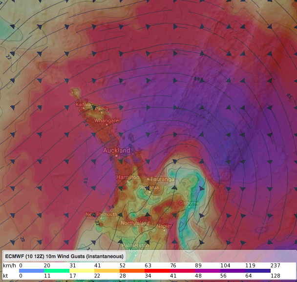
SWELLS
The storm surge with Hola is significant with current wave heights of 9 metres at sea.
As Hola moves into New Zealand swells near eastern Northland and East Cape could be around 4 to 6 metres. Storm surge is highest at the centre so if Hola’s centre remains out to sea that is a positive. ou can see below how the swells go from being extreme in a smaller area while north of NZ as a cyclone to being spread out with maximum heights dropping a little as the low changes shape around the north eastern North Island. This is more evidence the centre of the low is dramatically changing in the New Zealand area. Coastal erosion and damage is likely in some areas, especially when – or if – the peak winds, high tide and the centre of the low combine in one place at the same time. For now, that doesn’t appear to be the case but seas and coastal conditions will be extremely dangerous in some eastern and northern faces beaches/marine areas on Monday in the upper and eastern North Island.
1AM MONDAY:
10AM MONDAY: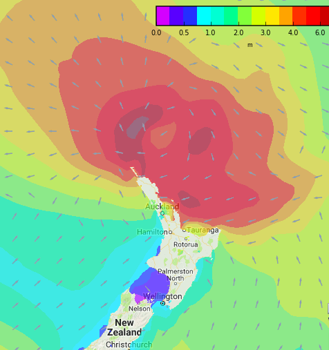
4PM MONDAY:
LATEST – AND FINAL – TRACKING OF TROPICAL CYCLONE HOLA (as of 4pm hour Sunday NZDT)
– JTWC
– Rain and swell maps courtesy of the Weathermap.co.nz team in New Zealand
– WeatherWatch.co.nz
Comments
Latest Video

VIDEO: RainWatch: Northern rain, then powerful high next week, but more rain next weekend?
A weak area of low pressure will move across the upper North Island this weekend and bring more welcome rain…
Related Articles

Weekend Newsfeed: Northern low. High pressure returning.
We’ve got a few moving parts to our weather over the weekend – but plenty of dry weather around too….
VIDEO: RainWatch: Northern rain, then powerful high next week, but more rain next weekend?
A weak area of low pressure will move across the upper North Island this weekend and bring more welcome rain…

VIDEO: A weak low for NZ on Saturday, high pressure next week
A low will move over the North Island on Saturday and fall apart – bringing patchy rain and showers across…


Add new comment