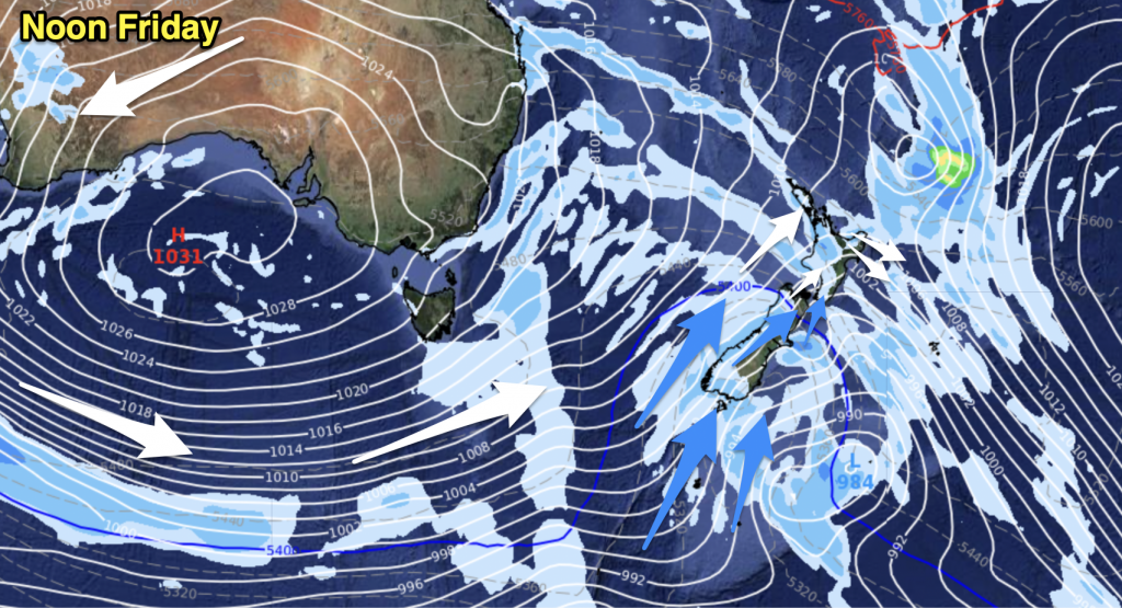
A strong westerly quarter airflow lies over the country today while a front moves northwards over both islands. Cold air moves onto the lower South Island today bringing low level snow later on.
Northland, Auckland, Waikato & Bay Of Plenty
Mostly cloudy with breezy westerly winds, winds becoming gusty to strong late afternoon / evening. The odd shower about mainly late afternoon and evening.
Highs: 15-17
Western North Island (including Central North Island)
Mostly cloudy with brisk westerly winds, strong about from afternoon in the west. Showers, more likely from afternoon then clearing around midnight.
Highs: 12-15
Eastern North Island
Sunny areas and some high cloud, northwesterly winds becoming strong in the afternoon especially about the Wairarapa where winds may gust to gale at times. Winds change southwest in the evening with some cloud and the risk of a shower.
Highs: 16-18
Wellington
Cloudy areas with strong northwesterly winds, gusting to gale at times. Winds change southerly in the evening with a period of showers.
High: 14
Marlborough & Nelson
High cloud with northwesterly winds, becoming strong during the morning. A few areas of rain spread into Nelson during the afternoon and possibly Marlborough, winds change southwest in the evening with cloud breaking away.
Highs: 14-16
Canterbury
High cloud and northwesterly winds, strong at times especially inland with gales possible. An early to mid afternoon southwest change brings a few showers some of which could be heavy with hail then mostly clearing in the evening. There may be some brief snow to 500 or perhaps 400m for a time as these showers ease late afternoon but by then amounts of precipitation are fairly low. Overnight a few flurries lower to 300m on Banks Peninsula.
High: 17
West Coast
Rain, easing to showers in the afternoon then clearing by evening. Some snow likely about the Fiordland Mountains. Northwesterlies change gusty southwest in the afternoon.
High: 12-13
Southland & Otago
Morning rain eases to wintry showers. Snow to 700m first thing then dropping to low levels (possibly sea level for Southland and the Catlins area) later in the evening. Expect small hail at times and a risk of thunderstorms too. Strong westerly winds gusting to gale at times in coastal areas then tending southwest late afternoon
Highs: 8-11
By Weather Analyst Aaron Wilkinson – WeatherWatch.co.nz


Add new comment
Guest on 11/06/2015 10:50pm
You say on weather video places will dry out????????…… theres next to no rain so what has to dry out?????
Reply