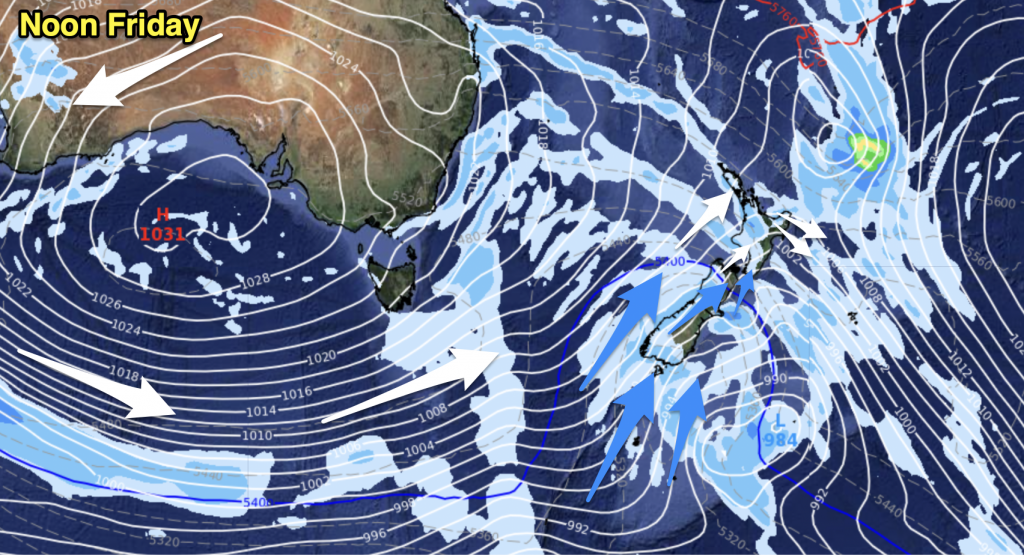
Very cold southwesterlies spread over the country today, snow to low levels affects southern parts of the South Island and some eastern areas. For the North Island most regions will experience showers for a time.
Auckland & Northland
Early rain clears then expect periods of cloud with brisk west to southwest winds, mid afternoon winds tend more southwest and become strong with a few showers moving in. Showers may be heavy at times about Auckland with a risk of hail.
Highs: 14-15
Bay Of Plenty
Early rain clears to mostly sunny weather, breezy westerlies. Winds tend
more southwest in the afternoon bringing some cloud (still sunny spells about),
chance of a brief shower or two late afternoon / evening.
more southwest in the afternoon bringing some cloud (still sunny spells about),
chance of a brief shower or two late afternoon / evening.
High: 14
Waikato & Central North Island
Early rain clears then sunny spells develop, breezy westerlies. Early
afternoon southwesterlies freshen with further showers which clear around
midnight. A few snow flurries lower to about 500m in the evening.
afternoon southwesterlies freshen with further showers which clear around
midnight. A few snow flurries lower to about 500m in the evening.
Highs: 10-13
Eastern North Island
Any early high cloud clears to mostly sunny weather, breezy west to
northwest winds. Gusty cold southwesterlies freshen in the afternoon bringing
occasional showers which clear for most later in the evening although remaining
about coastal Wairarapa. A few snow flurries lowering to 400m in the evening
however amounts will not be very significant, only a light dusting.
Highs: 13-14
Taranaki
Strong westerlies tend southwest by midday, mostly cloudy with occasional
showers. Small hail possible too. Clearing around midnight.
showers. Small hail possible too. Clearing around midnight.
High: 11
Western North Island
Mostly cloudy with brisk westerlies, the odd shower. Winds change gusty
southwest around midday with more widespread showers then easing in the evening.
Chance of some small hail with PM showers.
southwest around midday with more widespread showers then easing in the evening.
Chance of some small hail with PM showers.
High: 11
Wellington
Sunny spells first thing with brisk westerlies, winds change strong to gale
southerly late morning bringing wintry showers and small hail then clearing
early afternoon. Later this evening further showers move in with a chance of
hail again and the odd snow flurry to 400m then lowering to 300m overnight. Snow
will be light and nothing too significant above those levels.
southerly late morning bringing wintry showers and small hail then clearing
early afternoon. Later this evening further showers move in with a chance of
hail again and the odd snow flurry to 400m then lowering to 300m overnight. Snow
will be light and nothing too significant above those levels.
High: 10
Nelson
A few morning showers as brisk northwesterlies change southwest, clearing
midday then becoming mostly sunny in the afternoon.
midday then becoming mostly sunny in the afternoon.
High: 11
Marlborough
A few brief morning showers move through with a gusty southwesterly change
then sunny areas increase in the afternoon. About southern Marlborough expect
the odd shower to hang about for most of the day especially near the coast, the
odd snow flurry lowering to 200m in the afternoon.
then sunny areas increase in the afternoon. About southern Marlborough expect
the odd shower to hang about for most of the day especially near the coast, the
odd snow flurry lowering to 200m in the afternoon.
Highs: 9-11
Canterbury
Wintry showers develop early in the morning with a cold southwest change,
snow to 300m then clearing with sunny spells developing. Showers move in again
late afternoon / evening with a risk of hail and snow flurries to low levels.
Banks Peninsula / coastal areas will be more in the firing line with this
weather, inland areas while receiving the odd shower and snow flurry to low
levels conditions will not be too bad with precipitation not as intense. All
shower activity clears at night.
High: 9
West Coast
Showers with possible hail and snow to 300m clears by midday, sunny spells
increase from afternoon. Brisk cold southwesterlies ease overnight.
increase from afternoon. Brisk cold southwesterlies ease overnight.
High: 9
Coastal Otago
Wintry showers with snow to low levels, possibly sea level then clearing
evening. Strong cold southwesterly winds ease overnight.
evening. Strong cold southwesterly winds ease overnight.
High: 6
Central Otago
Wintry showers with snow for most, easing afternoon and clearing by
evening. Cold southwesterlies die out later in the day. Frosty overnight.
evening. Cold southwesterlies die out later in the day. Frosty overnight.
Highs: 4-5
Southland
Wintry showers with hail at times, snow to near or just on sea level.
Gradually easing during the day to clear by evening. Strong cold southwesterlies
ease evening dying out by midnight.
Gradually easing during the day to clear by evening. Strong cold southwesterlies
ease evening dying out by midnight.
Highs: 6-7
By Weather Analyst Aaron Wilkinson – WeatherWatch.co.nz


Add new comment